Montpelier is an inner-city Bristol neighbourhood known for its historic Georgian and early Victorian buildings, sloping streets, railway heritage, conservation area, parks and close connections with Stokes Croft, St Pauls, Cotham and Ashley. Its character developed from a semi-rural setting into a densely built residential district during the 19th century.
- What is Montpelier in Bristol?
- How did Montpelier develop historically?
- Why is Montpelier known for its architecture?
- What is the Montpelier Conservation Area?
- What historic buildings can you see in Montpelier?
- When did Montpelier railway station open?
- How can you travel around Montpelier?
- What parks and green spaces are in Montpelier?
- What is the significance of St Andrew’s Church to Montpelier?
- What is everyday life like in Montpelier?
- How does Montpelier connect with nearby Bristol neighbourhoods?
- Why is Montpelier important for Bristol’s heritage?
- What should visitors look for when exploring Montpelier?
- How can Montpelier’s heritage remain relevant in the future?
The area sits north of Bristol city centre and has a strong architectural identity. Streets such as York Road, Bath Buildings, Richmond Road and Montpelier Road contain historic terraces and villas. Montpelier railway station provides a rail connection, while local streets connect the neighbourhood with wider inner Bristol.
Montpelier also has several green spaces, including Montpelier Park and St Agnes Park. The area combines historic housing with everyday residential services, independent businesses and convenient access to central Bristol.
What is Montpelier in Bristol?
Montpelier is an inner-city Bristol neighbourhood centred around St Andrew’s Road, York Road, Bath Buildings, Richmond Road and Montpelier Road. It is recognised for historic architecture, a conservation area, railway heritage, parks and dense residential development.
Montpelier is part of the wider inner-northern Bristol urban area. It sits close to Stokes Croft, St Pauls, Cotham, Kingsdown and Ashley Down. The neighbourhood connects residential streets with major routes leading towards Bristol city centre and Gloucester Road.
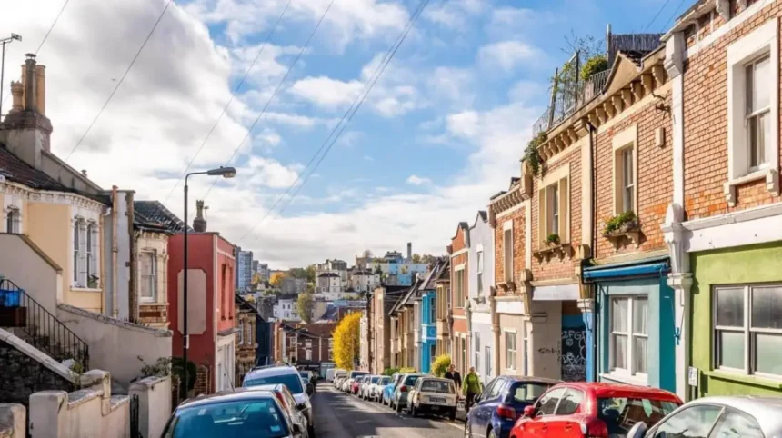
The physical character of Montpelier is strongly influenced by its hills and changing elevation. Bristol City Council’s character appraisal records slopes, historic road patterns, terraces, villas, gardens and views as important parts of the area’s townscape.
The neighbourhood is also associated with the Montpelier Conservation Area. Bristol City Council defines a conservation area as an area with special architectural or historic interest where character and appearance are desirable to preserve or enhance.
Montpelier therefore has significance beyond its residential function. Its streets provide a visible record of Bristol’s urban expansion during the Georgian and Victorian periods.

How did Montpelier develop historically?
Montpelier developed from a semi-rural area with villas, gardens and field tracks into a dense inner-city neighbourhood during the 19th century. Artists were attracted to the area during the 1820s and 1830s, while major development followed population growth and railway expansion.
During the early 19th century, Montpelier retained a relatively open landscape. Bristol City Council records that villas on the southern slopes had semi-rural surroundings and large gardens. Existing field tracks were improved while retaining much of their historic alignment.
The area began attracting artists during the 1820s and 1830s. By the end of the Georgian period, Montpelier had become a recognised place rather than simply an undeveloped edge of Bristol. The area was incorporated within Bristol’s city boundaries in 1835.
Early Victorian development initially remained relatively limited. Housing appeared on former nursery land around Bath Buildings, with additional terraces developing around Richmond Road and lower York Road.
The transformation accelerated during the 1860s and 1870s. Bristol experienced substantial population growth during this period. Montpelier changed from a semi-rural district into a densely developed inner-city neighbourhood. New houses occupied gardens, meadows and spaces between existing Georgian properties.
This historical sequence explains why Montpelier contains several architectural periods within a compact area.
Why is Montpelier known for its architecture?
Montpelier is known for Georgian and early Victorian terraces, villas, rendered houses, limestone details, sash windows, parapets and historic street layouts. York Road and Bath Buildings contain several listed buildings that demonstrate the area’s early 19th-century architectural development.
Architecture is one of Montpelier’s defining characteristics. The neighbourhood contains groups of buildings rather than isolated historic structures. This creates continuous streetscapes with shared materials, proportions and architectural details.
York Road is particularly significant. Numbers 14–34 form a Grade II-listed terrace of 11 houses dating from around 1830. Historic England describes the group as a complete row of modest early 19th-century terraced housing.
Number 40 York Road is another Grade II-listed house. It dates from around 1830 and has three storeys, an attic and basement, limestone dressings and historic sash windows.
Number 36 York Road dates from around 1820. Its features include a Doric portico, sash windows, parapet and basement-level frontage.
Bath Buildings also contains listed historic housing. Numbers 11–25 form a Grade II-listed terrace dating from around 1830. The properties feature rendered elevations, limestone ashlar details, pilaster strips, parapets and traditional sash windows.
These buildings demonstrate how Montpelier’s residential architecture developed around planned terraces and individual villas during the early 19th century.
What is the Montpelier Conservation Area?
The Montpelier Conservation Area protects the historic character of a defined part of the neighbourhood, including its buildings, streets, boundaries, views and other townscape features. It was designated in 1978 and subsequently extended several times.
Montpelier was designated as a Conservation Area on 15 March 1978. Bristol City Council records later extensions in July 1978, February 1981 and 2002. The council’s character appraisal also identifies further boundary changes associated with the appraisal process.
Conservation-area status does not mean that every building is individually listed. Instead, it protects the character of an area as a whole.
Bristol City Council identifies features such as historic road patterns, building materials, construction techniques, historic uses, green spaces, trees, street furniture and distinctive views as potential components of conservation-area character.
Property owners therefore need to consider heritage controls when undertaking certain external changes or development.
The council states that conservation areas have stricter planning controls than other areas. Major work requires a pre-application enquiry, while specific works to trees can require formal notice or further protection.
This framework helps maintain the architectural continuity that defines Montpelier.
What historic buildings can you see in Montpelier?
Historic buildings in Montpelier include early 19th-century houses on York Road, Bath Buildings and Richmond Road, along with terraces and villas around Montpelier Road. Many buildings use rendered elevations, limestone details, sash windows, parapets and traditional Georgian proportions.
York Road provides some of the clearest examples of Montpelier’s historic residential architecture.
York Cottage at 72 York Road is a Grade II-listed building dated 1822. Historic England records a plaque bearing the name and date, along with late Georgian architectural features.
Number 137 York Road, known as Goodrich House, dates from the late 18th or early 19th century. It has limestone ashlar, pilaster strips, a cornice and parapet, sash windows and a late Georgian design.
Richmond Road contains Montpelier Buildings at number 117. This Grade II-listed house dates from around 1823 and includes pilasters, a thin cornice, parapet and semicircular-arched doorway.
Montpelier Road also contains historic terraces. Numbers 1–7 and associated walls and railings at 89 Montpelier Road form a Grade II-listed group. The terrace includes four-storey housing over half-basements and historic cast-iron railings.
For visitors interested in architecture, these streets provide a concentrated view of Bristol’s 19th-century residential expansion.
When did Montpelier railway station open?
Montpelier railway station opened in 1874 during the neighbourhood’s rapid Victorian expansion. The station strengthened connections with Bristol’s wider railway network and contributed to further development around St Andrew’s Road and the surrounding streets.
Railway infrastructure became an important part of Montpelier’s history during the 19th century.
Bristol City Council records the opening of Montpelier Railway Station in 1874. The Montpelier Hotel was subsequently built on St Andrew’s Road to serve railway passengers.
The station appeared during a period when large parts of the neighbourhood were being developed. Housing expanded across previously undeveloped land, including areas around Ashley Road and the lower slopes of Montpelier.
Montpelier’s railway history forms part of the wider transformation of Bristol through industrialisation and improved passenger transport.
The wider Great Western Railway network had already connected Bristol with London in 1841. Historic England records the London-to-Bristol route as a major railway project engineered by Isambard Kingdom Brunel, with the Bristol section completed in June 1841.
Montpelier’s later station therefore developed within an established railway city.
How can you travel around Montpelier?
Montpelier is served by Montpelier railway station and a network of local roads connecting the neighbourhood with central Bristol and nearby districts. Walking, cycling, buses and rail provide the main transport options, while parking is subject to local restrictions and availability.
Montpelier station is located on Station Road. GWR lists facilities including bicycle parking, seating, public Wi-Fi, ticketing facilities and step-free access information for the station.
The neighbourhood’s compact urban form also supports walking. Streets connect residential areas with local shops, parks, railway facilities and neighbouring districts.
Cycling is another practical option for journeys around inner Bristol. The steep sections of Montpelier are an important consideration because the neighbourhood occupies rising ground.
Car travel requires attention to local parking arrangements. Bristol City Council’s local information tools provide information about resident parking schemes, nearby facilities and other neighbourhood-level data.
For visitors, checking current transport information before travelling is useful because rail services, road conditions, parking restrictions and temporary works change over time.
What parks and green spaces are in Montpelier?
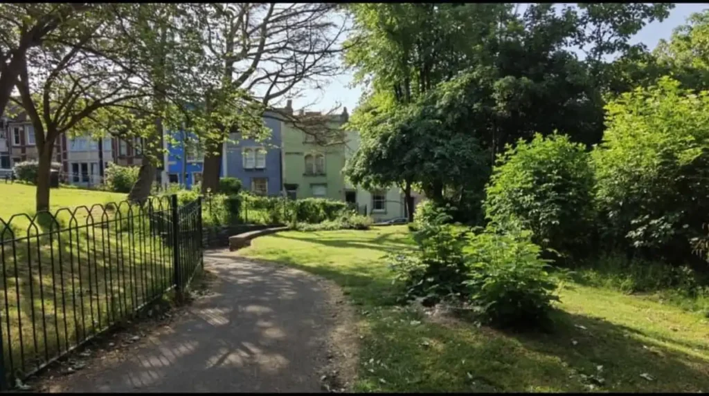
Montpelier has several accessible green spaces, including Montpelier Park and St Agnes Park. These spaces provide playgrounds, seating and community recreation within the dense urban neighbourhood, while historic churchyard land also forms part of Montpelier’s green-space story.
Montpelier Park is located on St Andrew’s Road. Bristol City Council states that the park stands on the former churchyard of St Andrew’s Church, which was demolished in 1969.
The park contains children’s play equipment, including climbing equipment, swings, slides, balancing facilities and picnic tables. Access is from St Andrew’s Road.
The site’s history is particularly important. St Andrew’s Church was constructed in 1844 and became an important local landmark. The church was demolished in 1969, and Montpelier Park subsequently occupied the site. The park’s boundary walls and mature yew trees retain reminders of the former churchyard.
St Agnes Park is another community green space. It is located on Thomas Street and includes a playground. Bristol City Council identifies it as a community park and states that it is open at all times.
These spaces provide recreation within a neighbourhood otherwise characterised by dense housing and urban streets.
What is the significance of St Andrew’s Church to Montpelier?
St Andrew’s Church was built in 1844 and became an important part of Montpelier’s Victorian development. The church was demolished in 1969, but its former churchyard became Montpelier Park, retaining walls, mature trees and elements of the historic site.
The church reflects the population growth that changed Montpelier during the Victorian period.
The building was added in 1844, followed by a large vicarage in 1862. These dates correspond with the period when housing development and population growth were transforming the neighbourhood.
The church was demolished in 1969. The former site was subsequently converted into Montpelier Park.
This history demonstrates how land uses change within established urban neighbourhoods. A former religious site now provides public open space while retaining physical evidence of its previous use.
The park’s boundary walls are former church walls. Mature yew trees also remain as landscape reminders of the former churchyard.
The site therefore connects Montpelier’s Victorian history with its modern community function.
What is everyday life like in Montpelier?
Everyday life in Montpelier combines dense historic housing, local services, public transport, green spaces and access to central Bristol. The neighbourhood supports residential life within walking distance of neighbouring inner-city districts, while its conservation status shapes the built environment.
Montpelier is primarily an urban residential neighbourhood. Housing includes historic terraces, villas, converted properties and later residential buildings.
The street network connects the area with Stokes Croft, St Pauls, Cotham, Kingsdown, Ashley Down and other parts of inner Bristol. This position places many services and destinations within the wider central Bristol urban area.
Local life is also shaped by the area’s architectural form. Narrow streets, terraces, slopes and historic boundaries create a distinctive physical environment.
The neighbourhood’s green spaces add recreational facilities without requiring residents to leave the area. Montpelier Park provides a playground and picnic facilities, while St Agnes Park provides another community recreation space.
The combination of housing, transport, parks and local services makes Montpelier a functioning residential district rather than a purely heritage-focused destination.
How does Montpelier connect with nearby Bristol neighbourhoods?
Montpelier sits within a connected group of inner Bristol neighbourhoods that includes Stokes Croft, St Pauls, Cotham, Kingsdown and Ashley Down. Its roads and railway station provide links between residential streets, local services and the wider city centre.
Stokes Croft lies to the south-west and provides a major inner-city corridor towards central Bristol.
St Pauls is also nearby, with the two neighbourhoods forming part of Bristol’s dense northern inner-city area.
Cotham lies towards the south and south-west, while Kingsdown occupies higher ground towards the central part of Bristol. Ashley Down lies further north.
These relationships are important when understanding Montpelier’s location. The neighbourhood does not operate as an isolated settlement. It forms part of a continuous urban area with overlapping transport routes, services and community facilities.
The historic Montpelier Conservation Area also sits within this wider urban context. Bristol City Council uses character appraisals to examine how topography, landscape, views, layout, architecture, materials, land use and social development shape neighbourhood character.
This approach helps explain why Montpelier’s identity depends on both individual buildings and its relationship with surrounding streets.
Why is Montpelier important for Bristol’s heritage?
Montpelier is important to Bristol’s heritage because it preserves evidence of the city’s 19th-century expansion through Georgian housing, Victorian development, railway infrastructure, historic streets and former institutional sites. Its conservation area provides formal recognition of this combined character.
Montpelier illustrates several stages of Bristol’s urban development within one neighbourhood.
The earliest surviving built character includes late Georgian and early 19th-century houses. Victorian expansion added terraces, streets, institutional buildings and railway infrastructure.
The railway station opened in 1874, while St Andrew’s Church had already been constructed in 1844. These landmarks correspond with the period of rapid population growth and urbanisation.
The area’s listed buildings provide statutory recognition for individual historic structures. Historic England’s National Heritage List for England includes numerous Montpelier properties, including buildings on York Road, Bath Buildings, Richmond Road and Montpelier Road.
The conservation area provides a broader layer of protection for the area’s collective character.
Bristol’s Historic Environment Record also contains information on historic buildings, monuments, archaeological investigations and historic landscapes. The database contains more than 7,000 entries across the city.
Explore More Area Guide
Hotwells Bristol Area Guide: History, Attractions and Local Life
Stoke Bishop Bristol: Area Guide, History, Homes and Attractions
What should visitors look for when exploring Montpelier?
Visitors exploring Montpelier should focus on its historic streets, listed buildings, railway station, former St Andrew’s Church site, parks and changing elevations. York Road, Bath Buildings, Richmond Road and Montpelier Road provide particularly strong examples of the neighbourhood’s historic built character.
A walking exploration can begin around Montpelier railway station and continue towards Station Road and St Andrew’s Road.
The next focus can be the historic housing around York Road. The street contains several listed buildings representing different stages of early 19th-century development.
Bath Buildings provides another architectural sequence. Its listed terrace dates from around 1830 and retains distinctive historic details.
Richmond Road adds further examples of early 19th-century housing, including Montpelier Buildings.
Montpelier Park provides a useful historical stop because its present landscape occupies the former St Andrew’s Church site. The remaining walls and mature trees connect the modern park with its Victorian past.
Walking through the neighbourhood also reveals the importance of topography. The changing elevation contributes to views, street layouts and the visual relationship between terraces and surrounding districts.
How can Montpelier’s heritage remain relevant in the future?
Montpelier’s heritage remains relevant through conservation planning, listed-building protection, historic research and responsible urban development. Future changes must balance housing needs, transport requirements, environmental improvements and modern building standards with the area’s established architectural and townscape character.
Montpelier’s conservation status provides an established planning framework for managing change. Bristol City Council states that conservation areas are intended to preserve or enhance special architectural and historic character.
Historic buildings also receive individual protection when they are listed. Listed-building status recognises structures with special architectural or historic interest and places them within England’s statutory heritage framework.
Future development therefore operates within several overlapping considerations. These include housing demand, accessibility, transport, environmental performance, public space, building maintenance and heritage conservation.
Bristol City Council’s character-assessment approach examines neighbourhood identity through physical and social factors. This includes topography, landscape, views, layout, architectural style, materials, land use and social development.
For Montpelier, this means future change is connected to the existing structure of the neighbourhood. Historic terraces, railway infrastructure, parks and street patterns remain important reference points.
The result is a neighbourhood where Bristol’s past remains visible within an active urban environment.
What is Montpelier in Bristol?
Montpelier is an inner-city Bristol neighbourhood known for its historic Georgian and Victorian buildings, conservation area, railway station, parks, residential streets and close connections with Stokes Croft, St Pauls, Cotham and Kingsdown.