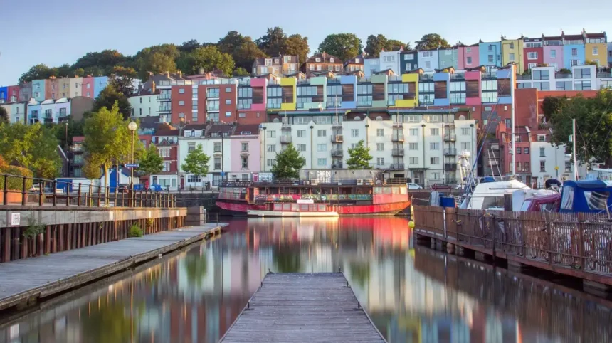
Hotwells is a historic riverside neighbourhood in west Bristol, positioned between Clifton, the Floating Harbour and the Avon Gorge. The area combines Georgian architecture, Bristol’s maritime heritage, waterfront paths, local community facilities and direct access to major landmarks such as Clifton Suspension Bridge.
- What is Hotwells in Bristol?
- How did Hotwells develop historically?
- Which historic buildings can you see in Hotwells?
- What are the main attractions near Hotwells?
- What can visitors do around Hotwells?
- How is Hotwells connected to Bristol Harbour?
- Is Hotwells a good place for families and everyday life?
- How easy is it to travel from Hotwells?
- What is Hotwells known for today?
- What is planned for Hotwells and Western Harbour?
- Why is Hotwells important to Bristol?
- What should visitors know before exploring Hotwells?
- How should a Hotwells visit fit into a Bristol itinerary?
Hotwells forms part of Bristol’s Hotwells and Harbourside ward and sits within the wider Clifton and Hotwells historic environment. Bristol City Council places the neighbourhood immediately east of the Portway, north of the Floating Harbour and west of central Bristol. The terrain rises sharply from approximately 10 metres above sea level beside the harbour to around 90 metres toward Clifton Park.
The area is also important within Bristol’s conservation history. The Clifton and Hotwells Conservation Area was designated on 26 September 1972 and subsequently extended in 1977 and 1981. Its buildings, streets, terraces, historic routes and relationship with the Avon Gorge form an important part of Bristol’s architectural character.
What is Hotwells in Bristol?
Hotwells is a west Bristol neighbourhood beside the Floating Harbour and Avon Gorge, known for its historic spa, Georgian terraces, maritime setting, steep streets, waterfront routes and proximity to Clifton Suspension Bridge and Bristol’s central harbour attractions.
Hotwells occupies a distinctive position between Bristol’s historic harbour and the elevated streets of Clifton. Hotwell Road follows the waterfront, while streets such as Granby Hill and Hope Chapel Hill climb towards Clifton.
The neighbourhood’s location explains much of its physical character. The Avon Gorge creates a dramatic western setting. The Floating Harbour defines the southern edge. Clifton rises to the north. The city centre lies to the east.
Hotwells is therefore both a residential neighbourhood and an important route through western Bristol.
The current administrative context is also relevant. Hotwells sits within the Hotwells and Harbourside ward, which Bristol City Council groups with Clifton, Clifton Down and Cotham under Area Committee 3.
The neighbourhood contains residential streets, historic buildings, waterfront facilities, childcare provision, play spaces, food and drink venues and maritime activity.
Its position also gives visitors convenient access to nearby destinations. Clifton Suspension Bridge, the Avon Gorge, Bristol Harbour, SS Great Britain, Spike Island and the wider Harbourside are all within the broader walking and transport network.
How did Hotwells develop historically?
Hotwells developed around a famous spa and medicinal spring, expanded through Georgian visitor accommodation, and later became closely connected with Bristol Harbour, transport routes, Clifton and Victorian urban development. Its surviving architecture records these changing roles.
The name Hotwells is associated with the area’s historic hot springs and spa. During the eighteenth century, the Hotwell became an important destination for visitors seeking the reputed health benefits of its waters.
The development of visitor accommodation followed the growth of the spa.
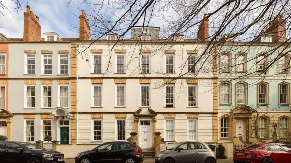
Dowry Square, begun around 1720 and dated 1721, was one of the earliest major developments connected with the Hotwell Spa. Bristol City Council describes it as accommodation intended for spa visitors. Its Grade II* listed buildings surround a central garden.
Dowry Parade followed in 1763. Chapel Row dates from approximately 1725–1727. These buildings demonstrate the transition from an informal riverside settlement into a planned Georgian residential and visitor district.
The spa itself declined as Clifton developed as a fashionable residential district. Bristol City Council’s historical material records the decline of the Hotwell spa during the nineteenth century as visitors increasingly stayed in Clifton’s new terraces.
The surviving Colonnade on Hotwell Road provides an important physical reminder of this period. Built in 1786 by Samuel Powell, it provided a sheltered promenade with shops beneath and living accommodation above. The structure is Grade II* listed.
The nineteenth century brought another major transformation. Bristol’s Floating Harbour was created between 1804 and 1809, fundamentally changing the relationship between the River Avon and the city. Cumberland Basin became an important part of the harbour system.
Hotwells subsequently became closely connected with maritime Bristol.
Which historic buildings can you see in Hotwells?
Hotwells contains surviving Georgian, Regency, Victorian and later historic buildings, including Dowry Square, Dowry Parade, Chapel Row, the Colonnade, Hope Chapel and historic terraces along Granby Hill and surrounding streets.
The area’s architecture reflects its changing economic and social functions.
Dowry Square
Dowry Square dates from the early eighteenth century and represents the period when Hotwells operated as a fashionable spa destination. Its three-sided arrangement and central garden remain important elements of the historic townscape.
Dowry Parade
Dowry Parade dates from 1763. Its red-brick terrace architecture demonstrates the Georgian expansion of Hotwells.
Chapel Row
Chapel Row dates from the 1720s and forms part of the early spa-related development surrounding Dowry Square. Several buildings retain architectural features associated with the period.
The Colonnade
The Colonnade is one of the clearest surviving physical links with the Hotwell Spa. Its thirteen-bay brick frontage and Tuscan colonnade remain visible along Hotwell Road.
Hope Chapel
Hope Chapel was founded in 1786 and enlarged in 1838. The former chapel now serves as a community facility. Its location on Hope Chapel Hill illustrates how religious, residential and community uses became integrated into the neighbourhood.
Granby Hill
Granby Hill follows an historic route connecting Hotwells with higher ground towards Clifton. A Regency terrace dating from 1822 survives at numbers 48–58, with architectural features including wrought-iron lamp brackets and canted oriel windows.
These buildings form part of the wider Clifton and Hotwells Conservation Area, where historic street patterns, buildings, views and landscape are considered in planning decisions.
What are the main attractions near Hotwells?
The main attractions around Hotwells include Clifton Suspension Bridge, the Avon Gorge, Bristol Harbour, Cumberland Basin, SS Great Britain, the historic Colonnade, waterfront facilities and nearby Clifton viewpoints and green spaces.
The neighbourhood works as a base for exploring several major Bristol landmarks.
Clifton Suspension Bridge
Clifton Suspension Bridge is the most prominent landmark associated with the wider Hotwells and Clifton landscape. The Grade I listed bridge crosses the Avon Gorge and opened on 8 December 1864.
The bridge has a total length of 414 metres and a central span of 214 metres. Its deck sits approximately 75.5 metres above high water.
Pedestrians, cyclists and horse riders cross without a toll. Motorised vehicles currently pay a £1 contactless toll. The toll supports the operation and maintenance of the privately managed bridge.
Avon Gorge
The Avon Gorge forms Hotwells’ dramatic western landscape. Its limestone geology and botanical significance make it important beyond its visual character.
Bristol City Council’s Clifton Down history material identifies the Avon Gorge as one of England’s leading botanical sites and highlights its Carboniferous limestone exposures.
Cumberland Basin
Cumberland Basin forms the western entrance to Bristol’s Floating Harbour. It contains lock gates, swing bridges, dockside infrastructure and historic maritime buildings.
Bristol City Council’s heritage assessment identifies two major phases of engineering at Cumberland Basin: the creation of the Floating Harbour between 1804 and 1809 and the major highway scheme constructed during the 1960s.
SS Great Britain
The SS Great Britain is one of Bristol’s major maritime attractions and sits within the wider harbour area. The vessel was designed by Isambard Kingdom Brunel and became a pioneering steamship associated with Bristol’s industrial and maritime history.
The surrounding harbour therefore provides a direct connection between Hotwells’ historic waterfront and Bristol’s wider industrial heritage.
What can visitors do around Hotwells?
Visitors can explore historic streets, walk beside the harbour, cross Clifton Suspension Bridge, visit maritime attractions, enjoy waterfront venues, access watersports and connect with nearby parks and viewpoints from Hotwells.
Walking is one of the most practical ways to understand the neighbourhood.
Hotwell Road provides a direct waterfront route. From here, visitors can connect with Cumberland Basin, the harbour entrance and routes towards the city centre.
The higher streets provide a different experience. Granby Hill, Hope Chapel Hill and neighbouring lanes demonstrate the steep topography that defines the area.
The historic character appraisal identifies several narrow lanes that historically connected Clifton with Hotwells and riverside ferry points. These include Polygon Lane, the access route near Hope Square and Hinton Lane.
The waterfront also supports recreational activity.
Bristol City Council’s Hotwell Road place plan identifies Young Bristol Pooles Wharf Activity Centre, where activities include kayaking, paddleboarding and canoeing.
The same plan identifies Mardyke Wharf and Capricorn Place as important maritime locations.
Hotwells therefore provides access to both land-based and water-based recreation.
How is Hotwells connected to Bristol Harbour?
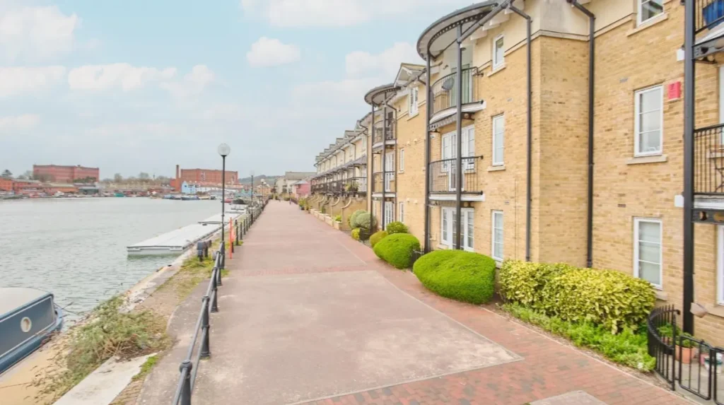
Hotwells is directly connected to Bristol Harbour through Hotwell Road, Cumberland Basin, harbour locks, waterfront landing points and maritime routes. This connection gives the neighbourhood an important role within Bristol’s historic and modern waterfront network.
Cumberland Basin is the seaward approach to Bristol’s Floating Harbour. From the mouth of the River Avon, the entrance lies 10.5 kilometres upriver. The harbour entrance includes the Entrance Lock, Cumberland Basin and Junction Lock.
Two swing bridges operate around Cumberland Basin. These are Plimsoll Bridge and Junction Bridge. Their operation supports both road movement and marine access.
Hotwells Road also contains maritime infrastructure.
Bristol City Council identifies Mardyke Ferry Landing and Capricorn Place Pontoon as significant waterfront locations. Mardyke Wharf dates from 1859 and historically supported trading and industrial maritime activity.
Today, the harbour supports leisure, tourism, residential moorings, watersports and marine businesses.
This continuity is significant because Hotwells has retained its relationship with the water despite major changes in industry and transport.
Is Hotwells a good place for families and everyday life?
Hotwells has residential streets, a primary school, childcare services, children’s play areas, community facilities and access to waterfront and outdoor spaces, giving families practical local amenities alongside strong connections with Clifton and central Bristol.
Hotwells Primary School serves children from the local area. Bristol City Council’s current school information lists Hotwells Primary School with a planned 2027 admission number of 30 and 144 pupils recorded on roll in January 2026.
The area also has childcare provision. Hotwells Children’s House operates from Hotwells Primary School on Hope Chapel Hill and provides early-years childcare.
Children’s outdoor facilities include Charles Place Play Area, which provides equipment for children aged from infancy through age 12, including swings, climbing equipment, spinning equipment and balancing equipment.
Argyle Place Park provides another small local play space between residential buildings, with climbing, rotating and spring equipment.
The neighbourhood’s physical structure affects everyday movement. Hotwell Road provides a relatively direct route along the waterfront, while streets climbing towards Clifton are considerably steeper.
This makes the area particularly distinctive for residents who regularly combine local amenities with walking routes.
How easy is it to travel from Hotwells?
Hotwells has strong road, walking, cycling and harbour connections, with Hotwell Road linking the waterfront to central Bristol and Cumberland Basin providing access towards the Portway, Clifton, Avonmouth and wider western Bristol.
The neighbourhood does not have a railway station. Local journeys therefore rely heavily on buses, walking, cycling, taxis, private vehicles and harbour transport.
Its road position is strategically important. Hotwells sits immediately east of the Portway and beside Cumberland Basin. Bristol City Council identifies the Portway as a major part of the area’s western setting.
The Clifton Suspension Bridge provides a direct crossing over the Avon Gorge into North Somerset and Leigh Woods. Pedestrians and cyclists can cross without paying the vehicle toll.
Harbour transport provides another option. Bristol Harbour’s ferry network connects different waterfront locations, and Bristol City Council’s waterspace planning identifies ferry services as an important part of the city’s wider harbour transport strategy.
The exact public transport timetable varies, so visitors should check current service information before travelling.
For drivers, Cumberland Basin is an important interchange. The area combines historic harbour infrastructure with modern road engineering introduced during the 1960s.
What is Hotwells known for today?
Hotwells is known today for its combination of historic architecture, waterfront living, maritime heritage, access to Clifton Suspension Bridge, harbour recreation, local community facilities and its strategic position between central Bristol and the Avon Gorge.
The neighbourhood has retained a strong physical relationship with its history.
The Georgian spa legacy remains visible in Dowry Square, Chapel Row, Dowry Parade and the Colonnade. The maritime legacy remains visible around Hotwell Road and Cumberland Basin.
Modern uses sit alongside these historic elements.
The Hotwell Road place plan identifies food and drink venues, maritime businesses, water-based activities and public waterfront space. It also highlights the mature tree-lined quayside as an important ecological feature.
The neighbourhood is also part of ongoing harbour planning.
Bristol City Council’s current Hotwell Road place plan proposes improvements to the quayside environment and identifies Mardyke Wharf for enhanced watersports activity, public space and commercial uses.
These plans connect Hotwells with the wider transformation of Bristol’s western harbour.
What is planned for Hotwells and Western Harbour?
Hotwells sits within the wider Western Harbour planning area, where Bristol City Council is examining future changes to transport, public space, waterfront access, development and the relationship between Cumberland Basin, Hotwell Road and surrounding neighbourhoods.
Western Harbour covers the western end of Bristol’s Floating Harbour.
Bristol City Council identifies an area including Hotwells Road, Dowry Place, Oldfield Place, the elevated road system, Cumberland Basin, parts of Spike Island and the Plimsoll Swing Bridge.
The wider regeneration process is significant because Cumberland Basin contains several overlapping systems. These include historic harbour infrastructure, major roads, pedestrian routes, marine facilities and residential areas.
The Hotwell Road place plan focuses specifically on improving the relationship between people and the waterfront.
Its stated future vision includes an improved quayside walk, stronger pedestrian access beside the water and improvements at Mardyke Wharf for watersports, public space and commercial activity.
Future changes therefore relate not only to new development but also to movement, public access and the conservation of historic character.
For visitors, the important point is that Hotwells remains part of an actively managed waterfront environment rather than a static historic district.
Why is Hotwells important to Bristol?
Hotwells is important because it connects Bristol’s Georgian spa history, harbour heritage, Victorian engineering, residential development and modern waterfront activity within a compact area beside the Avon Gorge and Floating Harbour.
Few Bristol neighbourhoods demonstrate such a concentrated sequence of historical development.
The eighteenth-century spa shaped streets and buildings around Dowry Square. The nineteenth century strengthened the connection with Clifton and major engineering projects. The Floating Harbour created a new maritime landscape. Cumberland Basin later gained major twentieth-century road infrastructure.
The Clifton Suspension Bridge added another defining layer when it opened in 1864. Designed by Isambard Kingdom Brunel and completed after his death, the bridge became a major piece of Bristol’s engineering heritage.
The bridge remains structurally significant. Its central span measures 214 metres and its deck stands roughly 75.5 metres above high water.
The conservation designation provides another layer of protection. Bristol has 33 conservation areas, and the Clifton and Hotwells Conservation Area is one of them. Conservation areas recognise places with special architectural or historic interest and influence planning decisions affecting their character.
Hotwells therefore has relevance for residents, visitors, historians, architecture enthusiasts, maritime enthusiasts and people exploring Bristol’s harbour landscape.
Explore More Area Guide
Stoke Bishop Bristol: Area Guide, History, Homes and Attractions
Westbury-on-Trym Bristol: History, Living, Transport and Things to Do
What should visitors know before exploring Hotwells?
Visitors should expect steep streets, historic buildings, busy roads around Cumberland Basin, waterfront paths, changing harbour conditions and a mixture of residential, recreational and maritime activity when exploring Hotwells and its surrounding attractions.
Comfortable footwear is useful because the neighbourhood rises sharply from the harbour towards Clifton.
The topography is one of Hotwells’ defining characteristics. Bristol City Council records a rise from around 10 metres above sea level beside the Floating Harbour to approximately 90 metres around Clifton Park.
Visitors crossing Clifton Suspension Bridge should also understand the toll arrangements. Motorised vehicles currently pay £1 by contactless payment, while pedestrians, cyclists and horse riders cross free.
The bridge operates as a privately managed historic structure. The Clifton Suspension Bridge Trust states that toll income funds its operation and maintenance.
Waterfront conditions also require awareness. Cumberland Basin contains working marine infrastructure, locks and swing bridges. Road traffic and harbour operations share the same environment.
For visitors interested in history, the best approach is to combine the main landmarks with the smaller architectural features. Dowry Square, Chapel Row, the Colonnade and Granby Hill provide important context for understanding why Hotwells developed in its present form.
How should a Hotwells visit fit into a Bristol itinerary?
A Hotwells visit works naturally as part of a west Bristol itinerary linking the historic neighbourhood with Clifton, the Avon Gorge, Clifton Suspension Bridge, Cumberland Basin and Bristol Harbour rather than treating the area as an isolated attraction.
A typical walking route can begin around the waterfront and move through Hotwell Road towards Cumberland Basin.
Visitors interested in architecture can then explore the historic streets leading towards Dowry Square and Clifton.
Visitors interested in engineering can continue towards Clifton Suspension Bridge and the Avon Gorge.
Maritime-focused itineraries can connect Hotwells with Cumberland Basin, the Floating Harbour and nearby harbour attractions.
The neighbourhood also works well as a connection between destinations. Its location beside the harbour and below Clifton makes it an important transition point between Bristol’s central waterfront and western Bristol.
This geographical position remains central to Hotwells’ identity.
Hotwells is therefore best understood as a historic waterfront neighbourhood, transport corridor, conservation area and gateway to the Avon Gorge. Its importance comes from the combination of these functions rather than from one individual attraction.
For anyone exploring Bristol, the area provides a compact view of Georgian spa history, maritime development, Victorian engineering, twentieth-century infrastructure and current waterfront regeneration.
Where is Hotwells in Bristol?
Hotwells is a historic neighbourhood in west Bristol beside the Floating Harbour and Avon Gorge. It sits between Clifton, Cumberland Basin and Bristol Harbour, with Clifton Suspension Bridge nearby.