Bristol is one of England’s most historically significant cities, with walking routes that reveal its medieval streets, maritime heritage, Georgian architecture, industrial development and cultural history. Its historic landscape connects centuries of trade, engineering, religion, literature and community life.
- What Makes Bristol an Important City for Historic Walking Routes?
- Which Historic Walking Routes Can Visitors Explore in Bristol?
- 1. Old City Heritage Trail
- 2. Redcliffe and Harbourside Historic Walk
- 3. Clifton and Clifton Suspension Bridge Walk
- 4. College Green and Brandon Hill Historic Walk
- 5. St James and Broadmead Heritage Walk
- 6. Barton Hill Heritage Trails
- How Does the Old City Heritage Trail Reveal Bristol’s Medieval History?
- Where Can Visitors Discover Bristol’s Maritime and Industrial History on Foot?
- Which Bristol Walking Routes Explain the City’s Social and Cultural History?
- How Can Visitors Explore Bristol’s Georgian and Victorian Architectural Heritage?
- What Longer Historic Walking Routes Are Available Around Bristol?
- How Should Visitors Plan a Historic Walking Tour of Bristol?
- Choose a route based on available time
- Download maps before starting
- Check walking surfaces and accessibility
- Use public transport where appropriate
- Prepare for changing weather
- Why Are Bristol’s Historic Walking Routes Important for Tourism and Heritage Preservation?
- Supporting local tourism businesses
- Preserving architectural heritage
- Improving historical understanding
- Encouraging sustainable tourism
- Which Resources Help Visitors Discover Bristol’s Historic Walking Routes?
Exploring Bristol on foot provides a direct way to understand how the city developed. Visitors encounter medieval churches, historic harbours, Victorian warehouses, Georgian terraces, former trading streets and internationally recognised landmarks. Each neighbourhood contributes a different part of Bristol’s identity.
Historic walking routes in Bristol suit tourists, local residents, families, students and anyone interested in British history. Routes range from short city-centre heritage trails to longer walks through Clifton, Redcliffe, the Harbourside and Bristol’s historic green spaces.
The city’s walking network also connects important attractions, including Bristol Cathedral, St Mary Redcliffe Church, Queen Square, the Clifton Suspension Bridge and M Shed. These locations provide insight into Bristol’s changing economy, architecture and social history.
What Makes Bristol an Important City for Historic Walking Routes?
Bristol is an important destination for historic walking because its streets preserve evidence of medieval settlement, maritime trade, industrial expansion, Georgian development and modern cultural change. Its historic buildings, harbour infrastructure and neighbourhoods provide accessible opportunities to explore centuries of British history.
Bristol developed as a significant trading settlement because of its position beside the River Avon and River Frome. Its waterways supported commercial connections with other British ports and international destinations. The city’s harbour became central to its economic development.
Medieval Bristol expanded around its castle, churches, markets and defensive walls. Merchants established businesses along important commercial streets, while religious institutions shaped the surrounding urban landscape.
The city’s prosperity increased during the medieval and early modern periods. Bristol became involved in international shipping, manufacturing and the movement of goods. Its commercial development also involved the transatlantic trafficking and enslavement of African people. This history remains essential to understanding Bristol’s historic buildings and wealth.
During the eighteenth century, Georgian architecture transformed areas such as Queen Square and Clifton. Wealthy merchants and professionals commissioned elegant townhouses, terraces and public buildings.
The nineteenth century introduced further changes through engineering, railway development, manufacturing and harbour improvements. Engineer Isambard Kingdom Brunel became particularly important to Bristol’s transport history through projects including the Clifton Suspension Bridge and the Great Western Railway.
Today, historic walking routes connect these different periods. Visitors can examine architectural details, discover former commercial districts and understand how Bristol developed into a major cultural and economic centre.
Visit Bristol provides maps and walking information for exploring the city’s central districts and surrounding attractions.

Which Historic Walking Routes Can Visitors Explore in Bristol?
Bristol offers several established historic walking routes covering medieval streets, Georgian neighbourhoods, maritime landmarks and industrial heritage. Important examples include the Old City Heritage Trail, Redcliffe and Harbourside walks, Clifton heritage routes, College Green and Brandon Hill, and historic community trails.
The most suitable route depends on the historical period, walking distance and attractions visitors want to experience.
1. Old City Heritage Trail
The Old City Heritage Trail explores the historic centre of Bristol and follows the approximate route of the city’s former medieval defensive walls.
This circular walk measures approximately 1 kilometre and takes around one to one-and-a-half hours, depending on how frequently visitors stop.
The route introduces visitors to Bristol’s medieval commercial development, religious history and architectural heritage. Although most of the original city walls have disappeared, sections and surviving historic buildings reveal the layout of medieval Bristol.
Important locations include:
- Broad Street and St John on the Wall Church.
- Corn Street and its historic commercial buildings.
- Wine Street and the surrounding Old City.
- The former medieval trading district.
- Historic architectural details above modern shopfronts.
The trail is particularly useful for visitors who want a short introduction to Bristol’s history without committing to a long walk.
Bristol Old City provides information about the route and its historical background.
2. Redcliffe and Harbourside Historic Walk
Redcliffe and the Harbourside offer a route through Bristol’s maritime, religious and industrial history.
St Mary Redcliffe Church is one of the area’s most significant historic landmarks. Its Gothic architecture reflects the importance of medieval Bristol and the wealth generated by its commercial connections.
The surrounding streets contain evidence of the city’s industrial and shipping past. Historic warehouses, former trading premises and harbour structures explain how Bristol’s waterways supported economic activity.
M Shed provides additional historical context through exhibitions about Bristol’s people, industries and communities.
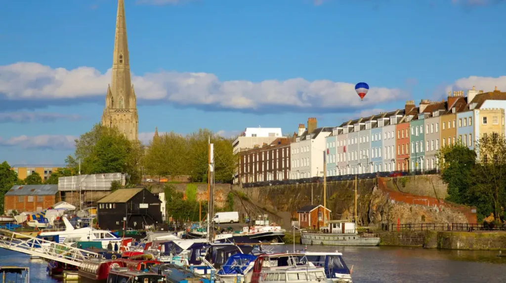
Visitors can also explore the waterfront around the Floating Harbour, which was developed to maintain water levels and improve the operation of Bristol’s port.
The route connects architecture with social history, including Bristol’s involvement in international trade and the transatlantic slave trade.
3. Clifton and Clifton Suspension Bridge Walk
Clifton offers a historic walking experience centred on Georgian architecture, Victorian engineering and the landscape of the Avon Gorge.
The Clifton Suspension Bridge is the area’s most recognisable landmark. Isambard Kingdom Brunel designed the bridge in the nineteenth century, with construction beginning in 1831. The bridge was completed and opened in 1864 under the supervision of engineers William Henry Barlow and John Hawkshaw.
The walking route connects several notable locations:
- Clifton Village and its Georgian streets.
- Clifton Observatory.
- The Avon Gorge viewpoints.
- Clifton Suspension Bridge.
- The Downs and surrounding open spaces.
Clifton’s architectural character reflects the development of an affluent residential district during the Georgian and Victorian periods.
The route also demonstrates the importance of engineering in Bristol’s history. The bridge remains a major transport and visitor landmark.
Historic England records the bridge’s engineering history and construction dates. Historic England+1
4. College Green and Brandon Hill Historic Walk
College Green and Brandon Hill provide a combination of religious, civic and architectural history.
Bristol Cathedral stands beside College Green and represents an important part of the city’s religious heritage. The surrounding area includes historic civic buildings and streets associated with Bristol’s administrative and cultural development.
The walk continues towards Park Street, where Georgian buildings reflect the city’s eighteenth-century expansion.
Brandon Hill offers elevated views across Bristol. Cabot Tower, completed in 1898, commemorates John Cabot’s 1497 voyage from Bristol towards North America.
This route connects important historical periods, from medieval religious institutions to Victorian commemorative architecture.
5. St James and Broadmead Heritage Walk
St James and Broadmead contain some of Bristol’s oldest surviving religious and archaeological heritage.
St James Priory dates from the Norman period and represents an important part of Bristol’s medieval religious history. Its location near the modern shopping district demonstrates how the city’s commercial landscape developed around older settlements.
The surrounding area also contains historical connections to Bristol Castle, Quaker communities and early Methodist activity.
This walk is suitable for visitors interested in the relationship between medieval Bristol and the modern city centre.
6. Barton Hill Heritage Trails
Barton Hill provides a different perspective on Bristol’s history through industrial development, working-class communities and neighbourhood change.
The Barton Hill History Group has developed heritage trails exploring local employment, community life and historical buildings.
Named trails include Work, Rest and Pray, Down The Brillas, Royalty and Rhubarb, and The Drain, The Train and The Wain.
These routes provide historical information beyond Bristol’s best-known central attractions. They help visitors understand the experiences of local residents and the development of East Bristol.
How Does the Old City Heritage Trail Reveal Bristol’s Medieval History?
The Old City Heritage Trail reveals Bristol’s medieval history by following the approximate line of its former defensive walls and connecting important streets, churches and commercial buildings. The circular route covers approximately one kilometre and takes around 60–90 minutes.
Medieval Bristol developed around important trading streets, religious buildings and defensive structures. Its urban layout reflected the importance of commerce, security and access to waterways.
The former town walls helped protect the settlement and define its boundaries. Although most sections disappeared through later development, the historic street pattern preserves elements of the medieval city’s organisation.
Important historical locations
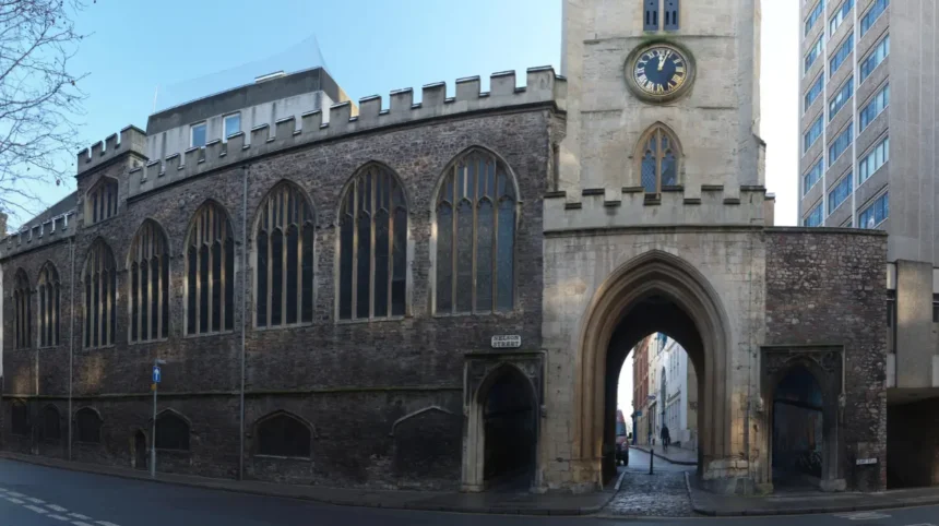
Broad Street provides one of the most recognisable connections to medieval Bristol. St John on the Wall Church stands beside the former defensive boundary and offers evidence of the city’s religious and architectural development.
Corn Street became an important commercial location. Its historic buildings reflect Bristol’s position as a trading centre.
Wine Street and nearby streets formed part of the historic commercial district. Their development illustrates how business activity shaped the medieval city.
The route also encourages visitors to examine architectural details above modern shopfronts. Carved decorations, historic façades and traditional street layouts provide evidence of earlier construction periods.
Why does the route matter?
The Old City Heritage Trail makes medieval Bristol easier to understand without requiring specialist historical knowledge.
It also demonstrates how modern retail, hospitality and cultural businesses operate within an older urban environment.
The official Old City guide describes the walk as a route around the former Norman Bristol walls, with historical information covering approximately 900 years of development. Bristol Old City+1
Where Can Visitors Discover Bristol’s Maritime and Industrial History on Foot?
Visitors can discover Bristol’s maritime and industrial history around the Floating Harbour, Redcliffe, Welsh Back, King Street and M Shed. These locations preserve evidence of shipping, commercial trade, engineering, manufacturing and the changing relationship between Bristol and its waterways.
Bristol’s maritime history is closely connected to the River Avon and the River Frome. Their waterways provided access to trading networks and supported the city’s development as a major port.
The Floating Harbour is one of the most important features of this historical landscape. Its construction helped address the difficulties caused by changing water levels and tidal conditions.
The Floating Harbour
Bristol’s Floating Harbour became operational in 1809. The harbour system maintained a more consistent water level for ships, improving the operation of the port.
Walking along the waterfront reveals historic industrial buildings, warehouses and former commercial premises.
The area also connects to modern cultural attractions, including M Shed and the surrounding Harbourside.
Welsh Back and King Street
Welsh Back was historically associated with Bristol’s maritime commerce. Its waterfront buildings provide evidence of the city’s trading activities and changing port infrastructure.
King Street contains historic buildings, traditional inns and cultural landmarks. The Bristol Old Vic, founded in 1766, is an important example of the city’s theatrical heritage.
Visitors can explore the surrounding streets to understand how entertainment, business and shipping developed together.
M Shed and Bristol’s industrial development
M Shed is a museum dedicated to Bristol’s history and communities. Its location beside the Floating Harbour makes it a useful starting or finishing point for a maritime heritage walk.
The museum explores the city’s development through transport, industry, trade and social change.
Nearby historic cranes provide visible evidence of the harbour’s former cargo-handling operations.
A walk through this district demonstrates how Bristol transformed its former industrial waterfront into a mixed cultural, commercial and recreational area.
Which Bristol Walking Routes Explain the City’s Social and Cultural History?
Bristol’s social and cultural walking routes explore the experiences of communities, religious groups, merchants, artists and workers. Important examples include the Trail of Remembrance, Seven Saints of St Pauls Trail, Barton Hill heritage walks and routes through historic cultural neighbourhoods.
Bristol’s history extends beyond its architecture and commercial achievements. Its development involved different communities whose contributions shaped the city’s identity.
Walking through historic neighbourhoods provides opportunities to understand migration, religion, employment, inequality, cultural expression and community activism.
The Trail of Remembrance
The Trail of Remembrance explores Bristol’s involvement in transatlantic chattel slavery.
The Diocese of Bristol developed this self-guided walking tour to examine the city’s connections with slavery and its continuing social consequences.
The route includes eight significant locations across central Bristol and takes approximately 1.5 hours to complete.
It includes a downloadable map and audio guide.
The trail examines the people and institutions that benefited from slavery, alongside the experiences and historical significance of enslaved Africans.
This route is important because Bristol’s maritime prosperity cannot be understood without acknowledging the exploitation that contributed to its commercial wealth.
It also provides an educational framework for examining contested heritage and racial justice.Diocese of Bristol
The Seven Saints of St Pauls Trail
The Seven Saints of St Pauls Trail celebrates the cultural history of Bristol’s Black communities and the contributions of the Windrush Generation.
The trail begins at the Roy Hackett mural on Byron Street in St Pauls.
It covers approximately 1.3 miles and is classified as an easy-to-moderate walk.
Artist Michele Curtis created the Seven Saints murals to recognise important contributions to the history of St Pauls Carnival and the wider community.
The route connects public art with local heritage, migration history and cultural identity.
It provides a valuable way to explore a part of Bristol’s history that traditional architectural tours often overlook.Visit Bristol+1
Barton Hill community history
Barton Hill’s heritage trails document working life, neighbourhood development and local identity.
The routes examine the relationship between employment, transport, religion and everyday community activities.
They provide an alternative to conventional city-centre sightseeing by focusing on the people who shaped Bristol’s residential and industrial neighbourhoods.
How Can Visitors Explore Bristol’s Georgian and Victorian Architectural Heritage?
Visitors can explore Bristol’s Georgian and Victorian architectural heritage through walking routes in Clifton, Queen Square, Park Street, College Green and the Harbourside. These districts contain historic terraces, churches, civic buildings, warehouses and major engineering landmarks.
Bristol’s architecture reflects the economic and social changes that occurred between the eighteenth and nineteenth centuries.
Georgian architecture became particularly prominent as the city expanded and wealthy residents commissioned substantial residential buildings.
Georgian Clifton
Clifton is recognised for its Georgian streets, terraces and residential architecture.
Royal York Crescent and the surrounding streets illustrate the area’s development as an affluent residential neighbourhood.
Clifton Village contains historic commercial buildings and smaller streets that complement the grander residential architecture.
The area provides an accessible walking environment for visitors interested in architectural design and urban history.
Queen Square
Queen Square is an important example of Bristol’s Georgian urban development.
Its planned layout and surrounding buildings reflect the city’s eighteenth-century prosperity.
The square also connects to Bristol’s commercial and maritime history because of its position near the historic waterfront.
Park Street and College Green
Park Street connects College Green with the higher areas of central Bristol.
Its historic buildings and established commercial character demonstrate the development of Bristol’s Georgian and Victorian city centre.
Nearby College Green and Bristol Cathedral add religious and civic context to the architectural route.
Clifton Suspension Bridge
The Clifton Suspension Bridge represents an important stage in Victorian engineering.
Brunel’s original design and the bridge’s eventual completion demonstrate the complexity of major nineteenth-century infrastructure projects.
Its position above the Avon Gorge also provides a strong connection between engineering history and Bristol’s natural landscape.
Historic England provides architectural and historical information about the bridge and other significant heritage structures.
What Longer Historic Walking Routes Are Available Around Bristol?
Bristol also offers longer walking routes that combine historic landmarks, waterways, parks and suburban heritage. The Bristol Ring, Bristol Bridges Walk and Clifton–Harbourside circular route provide opportunities to explore the city’s wider historical and geographical landscape.
Visitors with additional time can explore routes extending beyond the historic centre. These walks combine architectural attractions with riverside landscapes, historic estates and neighbourhoods.
The Bristol Bridges Walk
The Bristol Bridges Walk is a major walking challenge connecting 45 bridges across approximately 45 kilometres.
The route was devised by Dr Thilo Gross in 2013. It demonstrates a connection between Bristol’s geography and the mathematical Königsberg bridge problem, which concerns crossing a network of bridges without repeating a crossing.
The walk passes through different parts of the city and highlights its waterways, transport infrastructure and changing urban landscape.
Visitors do not need to complete the entire route in one day. Shorter sections provide opportunities to explore individual neighbourhoods and historic bridges.
The Bristol Civic Society provides route information and historical background.
The Bristol Ring
The Bristol Ring is a circular walking route measuring approximately 33 miles.
It is divided into six sections, with public transport access supporting different starting and finishing points.
Important locations along the route include:
- Troopers Hill Nature Reserve.
- Clifton Suspension Bridge.
- Nightingale Valley.
- Ashton Court Estate.
- Stoke Park Estate.
- Snuff Mills and the River Frome.
The route combines historic landscapes with green spaces and riverside environments.
Stoke Park Estate, Ashton Court and Clifton provide different perspectives on Bristol’s historical development, while the River Frome illustrates the relationship between the city and its natural waterways.
Visit Bristol recommends using the Go Jauntly app for route information.
Clifton, Hotwells and Harbourside Circular Walk
A circular walk connecting Clifton, Hotwells and the Harbourside provides an effective introduction to Bristol’s architecture, engineering and waterfront history.
A University of Bristol environmental history walking guide describes a 6.5-kilometre circular route taking approximately two hours.
The route begins near the university and includes Clifton, Clifton Suspension Bridge, Burwalls Wood, the New Cut of the River Avon, Underfall Yard, the Floating Harbour and Brandon Hill.
It also demonstrates how Bristol’s landscape influenced industrial and environmental development.
The route includes changes in elevation, woodland paths, steps and paved sections. Comfortable footwear is important.
The University of Bristol guide provides a useful historical and geographical overview of the walk.
How Should Visitors Plan a Historic Walking Tour of Bristol?
Visitors should plan a Bristol historic walking tour by selecting a suitable route, checking its distance and terrain, identifying accessible transport connections and reviewing opening arrangements for attractions. Downloadable maps and reliable heritage information help visitors navigate safely and understand historical landmarks.
Good preparation improves the experience and helps visitors avoid unnecessary walking.
Choose a route based on available time
The length of a historic walking route determines how many landmarks visitors can explore comfortably.
A short visit suits the Old City Heritage Trail, while a longer visit accommodates Clifton, Redcliffe or the wider Bristol Bridges Walk.
The following examples provide a practical guide:
- One hour: Explore the Old City and its medieval streets.
- Two hours: Visit Queen Square, King Street and the Harbourside.
- Three hours: Combine College Green, Park Street and Brandon Hill.
- Half a day: Explore Clifton Village, the Suspension Bridge and the Downs.
- A full day: Combine Redcliffe, the Harbourside, the Old City and additional historical attractions.
These are suggested planning periods rather than official route completion times.
Download maps before starting
Visit Bristol provides downloadable city maps and information about walking routes.
Its walking resources include the Bristol Bridges Walk, Bristol Heritage Taverns Trail and Harbour Trails.
Visitors can also use the Old City Heritage Trail guide and local heritage resources to identify significant historical locations.
The Know Your Place website, provided by Bristol City Council, offers access to historic maps, photographs and linked information about neighbourhoods.
This resource helps visitors compare historic Bristol with its modern street layout.Visit Bristol+1
Check walking surfaces and accessibility
Historic Bristol contains different types of walking surfaces.
Cobblestones, uneven pavements, steep streets, steps and woodland paths appear along different routes.
Clifton and Brandon Hill include changes in elevation. The Old City has relatively short walking distances, but some historic streets have uneven surfaces.
Visitors using wheelchairs or mobility aids should check individual route conditions before travelling.
The M Shed historical Old City walk describes most of its route as wheelchair-suitable while identifying some sections that present difficulties.
Use public transport where appropriate
Bristol’s historic neighbourhoods have connections to the city’s bus network and railway stations.
Temple Meads is a major railway arrival point, while central bus stops provide access to the Old City, College Green and Harbourside.
Visitors can also use public transport to access routes that start or finish in different neighbourhoods.
Checking current services through local transport information helps reduce unnecessary travel and supports flexible walking plans.
Prepare for changing weather
Bristol’s weather influences walking conditions throughout the year.
Waterfront paths become slippery during wet weather, while exposed areas around Clifton and the Downs experience stronger winds.
Suitable footwear, waterproof clothing and drinking water help visitors prepare for different conditions.
Longer routes require additional planning because facilities and refreshments are not available at every point.
Explore More Area Guide
Harbour Walks in Bristol: Best Routes and Waterfront Attractions
Riverside Walks in Bristol: Best River Avon and Harbour Routes
Why Are Bristol’s Historic Walking Routes Important for Tourism and Heritage Preservation?
Historic walking routes support Bristol’s tourism economy, preserve local identity and improve public understanding of the city’s development. They connect visitors with historic buildings, community stories and cultural landmarks while encouraging responsible exploration and appreciation of architectural heritage.
Walking tourism contributes to the wider visitor economy by directing people towards attractions, independent businesses, museums and hospitality venues.
Bristol’s historic districts benefit from visitors who explore beyond the main attractions. Routes through Barton Hill, St Pauls, Redcliffe and Clifton introduce neighbourhoods with different architectural and cultural identities.
Supporting local tourism businesses
Historic walking routes encourage visitors to spend time in different parts of Bristol.
Independent cafés, restaurants, shops, museums and cultural attractions benefit from pedestrian activity.
The Old City and King Street offer access to historic commercial streets, while Clifton Village provides opportunities to explore independent businesses alongside Georgian architecture.
The Harbourside connects heritage attractions with restaurants, museums and waterfront activities.
Preserving architectural heritage
Historic buildings require maintenance, conservation and appropriate development controls.
Bristol’s conservation areas help protect neighbourhood character and significant architectural features.
Historic England maintains records of nationally important historic buildings and structures. Its heritage information helps visitors identify significant locations and understand their historical value.
Bristol City Council’s Know Your Place resource also supports the investigation of historic buildings, maps and local heritage.
Improving historical understanding
Walking routes provide opportunities to examine difficult aspects of Bristol’s history.
The Trail of Remembrance addresses the city’s involvement in transatlantic slavery. The Seven Saints of St Pauls Trail celebrates Black history, migration and cultural contributions.
These routes expand historical understanding beyond famous buildings and wealthy merchants.
They also demonstrate the importance of including community experiences in local heritage interpretation.
Encouraging sustainable tourism
Walking allows visitors to explore multiple attractions without relying on private vehicles for every journey.
It supports active travel and reduces the need for short vehicle journeys between central attractions.
Bristol’s central pedestrian areas, public transport connections and established walking routes make this approach practical for visitors.
Longer routes such as the Bristol Ring also connect urban attractions with parks, nature reserves and historic estates.
Which Resources Help Visitors Discover Bristol’s Historic Walking Routes?
Visitors can use official tourism maps, local authority heritage records, museum walking guides and community-developed trails to discover Bristol’s historic walking routes. Visit Bristol, Bristol City Council, M Shed, Historic England and the Bristol Civic Society provide useful information.
Reliable resources help visitors understand historical landmarks and select routes suited to their interests.
The following organisations provide particularly useful information:
- Visit Bristol: Provides city maps, visitor information, heritage attractions and walking route suggestions.
- Bristol City Council: Provides information about local heritage, historic maps, parks and community walking trails.
- M Shed: Organises historical walks and provides information about Bristol’s social and maritime history.
- Historic England: Provides information about listed buildings, architectural heritage and nationally important historic structures.
- Bristol Civic Society: Publishes information about the Bristol Bridges Walk and the city’s built environment.
- Diocese of Bristol: Provides the Trail of Remembrance, including an audio guide and downloadable map.
- University of Bristol: Provides historical walking material exploring Bristol’s environmental and industrial landscape.
These sources provide a starting point for independent research and route planning. Visitors should check individual attraction opening times, guided tour availability and route conditions before travelling.
What are the best historic walking routes in Bristol?
The best historic walking routes in Bristol include the Old City Heritage Trail, Redcliffe and Harbourside Walk, Clifton Heritage Walk, College Green and Brandon Hill Walk, and Barton Hill Heritage Trails. Each route explores a different part of Bristol’s history.