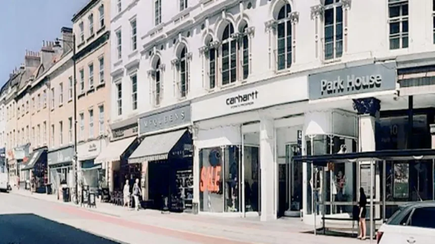
Park Street is a steep, historic retail corridor connecting Bristol city centre to Clifton, featuring an exceptional concentration of independent fashion boutiques, vintage clothing stores, record shops, cafes, and iconic Georgian architecture that attracts thousands of daily shoppers.
- Architectural history and urban layout of Park Street
- Retail profile and independent businesses on Park Street
- Transport accessibility and pedestrian footfall data for Park Street
- How does Gloucester Road function as Bristol’s primary independent shopping street?
- Historical development of Gloucester Road as an independent retail corridor
- Store composition and local business density on Gloucester Road
- Economic impact of independent trading on Gloucester Road
- What shopping options are available on Broadmead and Merchant Street?
- Post-war redevelopment and retail modernization of Broadmead
- High-street brands and anchor tenants on Broadmead and Merchant Street
- Integration with Cabot Circus and surrounding transport hubs
- Why is Clifton Village a premier destination for luxury shopping in Bristol?
- Georgian heritage and street network of Clifton Village
- High-end boutiques, antiques, and artisan retail in Clifton Village
- Demographics and visitor spend in Clifton Village
- What unique retail experiences does St Nicholas Market and the Old City offer?
- Historical significance of the Exchange and Corn Street market district
- Market stalls, artisan vendors, and indoor arcades
- Pedestrianization and footfall trends in Bristol Old City
- How do Christmas Steps and Colston Street contribute to Bristol’s historic retail landscape?
- Medieval urban structure of the Christmas Steps Arts Quarter
- Specialized craft shops, galleries, and niche traders
- Urban preservation and heritage commerce on Christmas Steps
- How do shoppers navigate and access Bristol’s main shopping streets?
Architectural history and urban layout of Park Street
Park Street was built between 1761 and 1784 to connect the lower city center with the hilltop district of Clifton. The street ascends at an inclination angle of 10 degrees, creating a distinct sloping thoroughfare that framed historic vistas of the city. Bombing during the Bristol Blitz of 1940 damaged several original structures, prompting structural restoration during the 1950s that preserved the Georgian stone facades. The street spans approximately 350 meters in length from the College Green perimeter at its base to the Wills Memorial Building at its apex. This historic architectural framework houses multistory retail properties with ground-floor glass shopfronts and upper-level commercial spaces.
Retail profile and independent businesses on Park Street
Park Street contains over 50 distinct commercial premises, with independent retailers occupying over 60 percent of total floor space. The retail mix emphasizes vintage fashion, music media, lifestyle design, and contemporary apparel. Notable independent retailers include Uncle Sam’s American Vintage, which has traded continuous retro fashion since 1984, and Very Olde English Sweets. The street also features established lifestyle brands including Patagonia, Barbour, and Waterstones. Complementing the retail inventory are educational and creative hubs such as the Bristol Folk House, a adult education center operating since 1920.
Transport accessibility and pedestrian footfall data for Park Street
Pedestrian activity on Park Street averages between 12,000 and 18,000 movements per day during peak retail periods. The street is served directly by First Bus routes 1, 2, 8, and 9, which connect Bristol Temple Meads railway station—located 1.2 miles to the southeast—directly to the University of Bristol precinct. Pay-and-display street parking exists along adjacent side streets, including Trenchard Street and Great George Street, while the Trenchard Street Multi-Storey Car Park provides 954 parking spaces within 200 meters of the retail strip. Pedestrian pavements measure between 3 and 4.5 meters in width, accommodating continuous foot traffic along the incline.
How does Gloucester Road function as Bristol’s primary independent shopping street?
Gloucester Road forms Europe’s longest continuous strip of independent shops, operating as a 1.5-mile commercial artery defined by zero high-street chain dominance, diverse local traders, street art installations, and community-owned commercial infrastructure.
Historical development of Gloucester Road as an independent retail corridor
Gloucester Road developed during the 19th century as the primary northern turnpike route out of Bristol toward Gloucestershire. Urban expansion between 1860 and 1910 filled the road with Victorian and Edwardian terraced shopfronts, creating a continuous commercial ribbon running through the neighborhoods of Bishopston, Horfield, and St Andrews. The street avoided large-scale post-war commercial clearance projects, preserving its original small-footprint retail units. This structural continuity enabled small business owners to secure accessible commercial leases, establishing the foundation for its current independent eco-system.
Store composition and local business density on Gloucester Road
Gloucester Road houses over 300 individual businesses along its 1.5-mile length, with independent operations comprising 80 percent of all commercial addresses. The retail mix includes green grocers, bakeries, hardware suppliers, bookstores, clothing boutiques, and home decor outlets. Three specific examples of long-standing independent establishments are:
- The Bristol Standard: A community-focused retail print and design studio.
- Scoopaway: An eco-friendly bulk wholefood retailer operating since 1989.
- Last Bookshop: A specialized independent seller of remaindered books and literature.
In addition, the street features four specialized vintage stores: Gloucester Road Vintage, Re-Psycho, Shelter Boutique, and Dusty Shreds.
Economic impact of independent trading on Gloucester Road
The commercial viability of Gloucester Road is supported by the Bristol Pound initiative—a local currency system launched in 2012 that circulated millions in local purchasing power—and active trader associations like the Gloucester Road Traders Association. Economic studies indicate that £10 spent in an independent store on Gloucester Road retains £8 within the local Bristol economy, compared to less than £3 spent at multinational chains. High occupancy rates exceeding 95 percent demonstrate continuous retail demand, while street art installations, including original works by Banksy, drive cultural tourism that supplements local residential patronage.
What shopping options are available on Broadmead and Merchant Street?
Broadmead and Merchant Street represent Bristol’s central pedestrianized retail core, providing open-air shopping, national department stores, major international fashion chains, essential service providers, and direct access to modern shopping centers.
Post-war redevelopment and retail modernization of Broadmead
Broadmead was transformed into Bristol’s primary commercial district during the 1950s following severe damage to the city’s historic shopping district in Wine Street and Castle Street during World War II. City planners constructed broad, multi-lane retail thoroughfares designed specifically for high-capacity pedestrian movement. In 1981, Broadmead became fully pedestrianized, removing vehicular traffic to create a safe, open-air retail zone. The total floor space of the Broadmead shopping area exceeds 1,500,000 square feet, positioning it as the largest concentrated retail district in the West of England region.
High-street brands and anchor tenants on Broadmead and Merchant Street
Broadmead and Merchant Street house major national and international retail brands that cater to general consumer demand. Key high-street retailers operating on Broadmead include Marks & Spencer, Boots, Primark, Decathlon, and TK Maxx. Merchant Street intersects Broadmead perpendicularly, housing essential service providers, value retailers, and specialty stores. Three prominent retail locations along Merchant Street include:
- Sainsbury’s Local: A central urban grocery location serving daily shoppers.
- Metro Bank: A flagship financial retail branch providing extended high-street banking services.
- Wilko: A long-standing homeware and hardware supply location.
The district features over 80 major retail units, offering apparel, cosmetics, consumer electronics, and home furnishings.
Integration with Cabot Circus and surrounding transport hubs
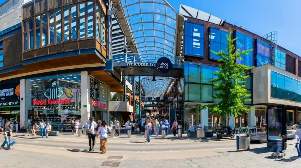
Broadmead connects directly with Cabot Circus, a £500 million indoor-outdoor shopping complex opened in September 2008 that added 1,000,000 square feet of retail and leisure space. Pedestrian routes link Broadmead to the Broadmead Multi-Storey Car Park (480 spaces) and the Cabot Circus Car Park (2,500 spaces). The district sits 0.5 miles north of Bristol Temple Meads station and is bordered by the Bristol Bus Station on Marlborough Street, which serves local First Bus routes as well as regional National Express services.
Why is Clifton Village a premier destination for luxury shopping in Bristol?
Clifton Village offers an exclusive luxury shopping experience characterized by Georgian and Victorian architecture, high-end fashion boutiques, fine antique dealers, artisan jewelry designer-makers, and upscale lifestyle shops within an affluent residential enclave.
Georgian heritage and street network of Clifton Village
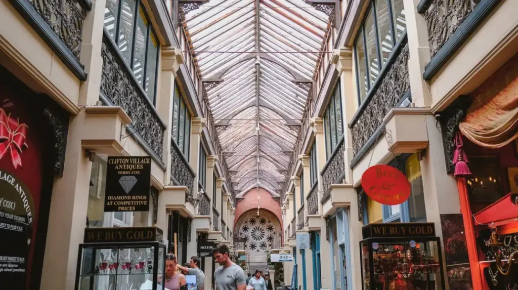
Clifton Village centers on Princess Victoria Street, The Mall, and Royal York Crescent, which were developed between 1790 and 1840. The area features pristine Georgian terraces and Victorian arcades built from Bath stone. The urban layout incorporates wide footpaths, landscaped squares, and original ironwork railings. The Clifton Arcade, constructed in 1887 by architect Joseph Chiswell, represents a preserved Victorian shopping arcade containing two stories of small-scale commercial premises under a glass vaulted roof.
High-end boutiques, antiques, and artisan retail in Clifton Village
The commercial footprint of Clifton Village emphasizes premium goods, artisan crafts, and specialized services. Independent boutiques present curated apparel, bespoke jewelry, interior furnishings, and rare books. Four primary examples of premier luxury establishments in Clifton Village are:
- Diana Porter Contemporary Jewellery: A gallery and workshop producing handmade precious metal jewelry.
- The Guild: A multi-floor design department store operating since 1908 that sells contemporary furniture, textiles, and homewares.
- Focus On Design: A luxury interior design studio and home furnishings showroom.
- Clifton Antiques Mall: A multi-dealer location housing over 50 specialized antique vendors.
Fine food purveyors include the Clifton Cellars wine merchant and Arch House Deli.
Demographics and visitor spend in Clifton Village
Clifton Village benefits from strong local spending power, supported by the surrounding Clifton ward where median household incomes exceed the Bristol city average by more than 35 percent. Tourism associated with the nearby Clifton Suspension Bridge—located 400 meters to the west—draws over 500,000 visitors annually. Footfall data shows consistent weekend retail trade, with peak visitor density occurring between 11:00 AM and 4:00 PM on Saturdays. The area is served by First Bus routes 8 and 9, connecting directly to the city center and Bristol Temple Meads.
What unique retail experiences does St Nicholas Market and the Old City offer?
St Nicholas Market and the Old City deliver Bristol’s premier historical retail experience, combining Britain’s largest collection of independent market stalls, historic arcade shopping, specialized craft vendors, and regional food traders within a 1743 glass exchange building.
Historical significance of the Exchange and Corn Street market district
St Nicholas Market occupies The Exchange on Corn Street, designed by architect John Wood the Elder and opened in 1743. The building served historically as a commercial grain and mercantile exchange before transitioning into a municipal market district. Corn Street and its surrounding arterial lanes—including Broad Street, Small Street, and Clare Street—form the medieval core of Bristol’s Old City. The bronze “Nails” outside The Exchange, dating from 1595 to 1642, served as historic trading tables where merchants completed financial transactions, originating the phrase “pay on the nail.”
Market stalls, artisan vendors, and indoor arcades
St Nicholas Market contains over 60 independent businesses divided into three distinct architectural sections: the Glass Arcade, the Covered Market, and the Exchange Hall. The market offers handcrafted leather goods, vintage apparel, original artwork, rare coins, and books. Three specific market stalls representing long-term operators include:
- Wanted Records: A specialized retailer dealing in rare vinyl records and obscure music releases.
- Treasure Island Sweets: A traditional confectionery vendor trading classic British sweets.
- Ahh Toots: An artisan bakery operating within the historic market frame.
The outdoor Farmers’ Market operates on Corn Street every Wednesday, presenting organic produce from within a 40-mile radius of Bristol.
Pedestrianization and footfall trends in Bristol Old City
The Old City district underwent full pedestrianization between 2020 and 2022, removing motor vehicle access from Corn Street, Broad Street, and St Nicholas Street during core trading hours. This urban change increased outdoor seating capacity by 40 percent and expanded pedestrian space. Daily footfall through St Nicholas Market exceeds 10,000 visitors on weekdays and 15,000 on Saturdays. The district is located 0.4 miles from Bristol Temple Meads station and connects directly to the floating harbor retail zone at Welsh Back.
Explore More Area Guide
Best Charity Shops in Bristol for Affordable Shopping, Furniture, Books and Vintage Finds
Best Markets in Bristol: Top Food, Vintage & Local Shopping Guide 2026
How do Christmas Steps and Colston Street contribute to Bristol’s historic retail landscape?
The Christmas Steps Arts Quarter offers a steep, step-cut medieval shopping lane that houses specialized craftspeople, printmakers, antique restorers, custom shoemakers, and independent art galleries operating in listed 17th and 18th-century buildings.
Medieval urban structure of the Christmas Steps Arts Quarter
The Christmas Steps street was originally constructed in 1669 by merchant Jonathan Blackwell, replacing a steep muddy track known as Kynpesley. The street consists of 84 stone steps divided into four flights, flanked by Grade II and Grade II* listed buildings. The narrow passage measures 2.5 meters in width, creating an exclusively pedestrian environment free from vehicular access. The surrounding Arts Quarter includes Colston Street, Perry Road, Lower Park Row, and Host Street, forming a historic urban zone preserved from modern commercial redevelopment.
Specialized craft shops, galleries, and niche traders
The retail profile of the Christmas Steps Arts Quarter focuses on specialized artisanal crafts, artistic production, and rare goods. Businesses operating on the steps maintain working workshops on premises where goods are produced directly for consumers. Four key examples of specialized retailers in the Christmas Steps Arts Quarter are:
- I Am Shoemaker: A bespoke leather footwear producer creating custom handmade shoes.
- 20th Century Flicks: The world’s longest continuously operating video rental archive, established in 1982 and housing over 20,000 titles.
- Focus Gallery: An independent art gallery showcasing regional paintings, ceramics, and sculptures.
- Folk House Cafe & Bar: An artisan food facility integrated with local creative workshops.
Additional businesses include custom stained-glass restorers, instrument repairers, and horologists.
Urban preservation and heritage commerce on Christmas Steps
The Christmas Steps Traders Association coordinates conservation efforts with Historic England to maintain the historic integrity of shopfronts and stone pavements. Commercial lease structures in this district accommodate micro-enterprises requiring low square footage, with floor plans typically ranging between 150 and 400 square feet. The lack of vehicular access preserves quiet foot traffic, attracting heritage tourists, art collectors, and shoppers looking for non-mass-produced items. The district lies 300 meters west of Broadmead and 400 meters north of the Floating Harbour.
How do shoppers navigate and access Bristol’s main shopping streets?
Navigating Bristol’s shopping streets relies on an integrated transport network comprising municipal bus routes, dedicated park-and-ride facilities, central multi-storey parking structures, navigable pedestrian zones, and direct rail connections via Bristol Temple Meads.
Public transit integration and bus routes across Bristol retail zones
First Bus West of England operates the primary public transport network connecting Bristol’s shopping streets. Key routes provide direct links between retail districts:
- Routes 1 and 2: Connect Bristol Temple Meads station through Broadmead, Park Street, and Whiteladies Road to Clifton.
- Routes 70, 73, 75, and 76: Connect Bristol Temple Meads and the central bus station directly to Gloucester Road.
- Routes 8 and 9: Form a continuous loop linking the railway station to the City Centre, Park Street, and Clifton Village.
Three Park-and-Ride sites—located at Brislington (A4), Portway (A4018), and Long Ashton (M5 junction 18)—operate electric express buses delivering shoppers directly into the Broadmead and Center shopping zones every 12 to 15 minutes.
Parking facilities and clean air zone compliance for shoppers
Drivers accessing Bristol’s shopping streets must navigate the Bristol Clean Air Zone (CAZ), implemented in November 2022. Non-compliant vehicles (older diesel and petrol cars) incur a daily fee of £9 when entering the central city zone, which encompasses Broadmead, the Old City, Park Street, and lower Clifton. Parking facilities near major shopping streets include five primary structures:
- Cabot Circus Car Park: 2,500 spaces adjacent to Broadmead.
- Trenchard Street Car Park: 954 spaces adjacent to Park Street and Christmas Steps.
- Galleries Car Park: 1,000 covered spaces within the Broadmead retail core.
- West End Car Park: 750 spaces serving the upper Park Street and University district.
- Clifton Down Shopping Centre Car Park: 350 spaces serving Whiteladies Road and Clifton.
Pedestrian infrastructure and walking distances between shopping districts
Bristol’s central shopping zones are linked by designated pedestrian corridors. Walking distances between major shopping streets measure as follows:
- Broadmead to St Nicholas Market: 0.3 miles (6-minute walk via Union Street).
- St Nicholas Market to Christmas Steps: 0.3 miles (6-minute walk via Colston Avenue).
- Christmas Steps to Park Street: 0.4 miles (8-minute walk via Pipe Lane or St Michael’s Hill).
- Park Street to Clifton Village: 0.8 miles (16-minute walk via Queens Road).
- Broadmead to Gloucester Road: 1.2 miles (24-minute walk or 8-minute bus ride via Stokes Croft).
Wayfinding signage pillars installed by Bristol City Council provide maps, walking times, and directional cues at 150-meter intervals throughout all central shopping districts.
What are the best shopping streets in Bristol for independent shops?
The best shopping streets in Bristol for independent shopping include Park Street, Gloucester Road, Clifton Village, St Nicholas Market, and the Christmas Steps Arts Quarter. These areas are known for independent boutiques, vintage stores, artisan shops, specialist retailers, cafes, and local markets offering products that are different from typical high-street chains.