Bristol is a major city in South West England with a diverse mix of historic districts, residential suburbs, urban villages and outer neighbourhoods. The city combines Georgian and Victorian architecture, green spaces, independent shopping streets, universities, employment centres and strong connections across the wider Bristol region.
- What are the best suburbs of Bristol for different lifestyles?
- Why is Clifton one of Bristol’s most recognised residential areas?
- Why is Redland a popular suburb for Bristol residents?
- What makes Bishopston one of the best suburbs of Bristol?
- Why do people choose Henleaze as a Bristol suburb?
- What makes Westbury-on-Trym a desirable Bristol suburb?
- Why is Stoke Bishop considered a suburban part of Bristol?
- Why is Southville an important residential area in Bristol?
- What makes Brislington a practical Bristol suburb?
- How do Bristol suburbs differ in housing and property types?
- Which Bristol suburbs have the strongest access to green space?
- How important is transport when choosing a Bristol suburb?
- How should visitors and prospective residents compare Bristol suburbs?
- How are Bristol’s suburbs changing?
- Which Bristol suburbs are most suitable for first-time buyers, families and professionals?
- What are the main alternatives to Bristol’s established suburbs?
- What should you check before choosing one of the best suburbs of Bristol?
The phrase best suburbs of Bristol covers several different types of residential areas. Clifton and Redland provide established urban neighbourhoods close to central Bristol. Henleaze, Westbury-on-Trym and Stoke Bishop provide a more suburban setting in the north and west. Bishopston combines residential streets with an active local shopping area. Southville provides a dense residential environment south of the city centre, while Brislington offers a larger suburban setting toward the eastern side.
Bristol City Council officially divides the city into wards and local areas. Its current area committee structure places Stoke Bishop, Westbury-on-Trym and Henleaze, Redland, and Bishopston and Ashley Down within Area Committee 2. Clifton, Clifton Down and Cotham sit within Area Committee 3. Southville and Bedminster sit within Area Committee 7, while Brislington East and Brislington West are part of Area Committee 9.
Housing costs are an important part of any comparison. The Office for National Statistics recorded an average Bristol house price of £352,000 in July 2026, while the average private rent reached £1,883 per month in August 2026. The average first-time-buyer price was £313,000. These figures apply to the Bristol local authority rather than individual suburbs, so neighbourhood-level prices vary considerably.
What are the best suburbs of Bristol for different lifestyles?
The best Bristol suburbs depend on location, housing type, transport, green space and local amenities. Clifton, Redland, Bishopston, Henleaze, Westbury-on-Trym, Stoke Bishop, Southville and Brislington provide distinct residential environments across the city. Each area suits different priorities rather than one universal definition of best.
A suburb close to Bristol city centre suits people who prioritise access to employment, culture, restaurants and universities. Clifton, Redland and Bishopston provide this combination through their position north and west of the central area.
More spacious suburban environments appear farther from the centre. Henleaze, Westbury-on-Trym and Stoke Bishop have established residential streets, larger properties and access to green spaces.
South Bristol provides another residential pattern. Southville and neighbouring Bedminster combine established housing with local shops, cafés and improved walking and cycling infrastructure. Bristol City Council has identified Totterdown, Southville and Bedminster East as priorities within the first phase of its South Bristol Liveable Neighbourhoods project.
East Bristol has its own suburban character. Brislington connects residential areas with major roads, local services and access toward the city centre and surrounding communities.
Bristol’s neighbourhood structure is also shaped by historic development. The council describes the city’s character through distinct neighbourhoods and conservation areas influenced by topography, landscape, architecture, land use and social development.
Why is Clifton one of Bristol’s most recognised residential areas?
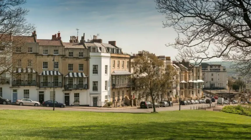
Clifton is one of Bristol’s most established residential districts, known for Georgian and Victorian architecture, Clifton Village, green spaces, proximity to the city centre and access to landmarks such as Clifton Suspension Bridge. Its central location makes it particularly significant within Bristol’s residential landscape.
Clifton occupies elevated ground west of Bristol city centre. Its streets contain substantial Georgian and Victorian buildings, terraces, villas and converted properties.
The area includes Clifton Village, a historic shopping and residential quarter with independent businesses and narrow streets. Nearby Clifton Down provides extensive open space and connects the district with surrounding northern neighbourhoods.
Clifton’s architectural identity is closely connected with Bristol’s expansion during the Georgian and Victorian periods. Large residential properties were constructed as Bristol developed into an important commercial and maritime city.
The neighbourhood also benefits from its proximity to major attractions. Clifton Suspension Bridge, designed by Isambard Kingdom Brunel and opened in 1864, crosses the Avon Gorge between Clifton and Leigh Woods.
Clifton’s location creates relatively direct access to central Bristol. The University of Bristol campus is close to the northern and eastern edges of the neighbourhood. The city centre is also accessible by walking, cycling and bus services.
Housing includes flats, converted period buildings, terraced houses and larger historic properties. The area’s architecture and central position contribute to strong residential demand.
The council places Clifton, Clifton Down and Cotham within Area Committee 3, alongside Hotwells and Harbourside.
Why is Redland a popular suburb for Bristol residents?
Redland is a residential area north of Bristol city centre with Victorian housing, green spaces, local businesses and strong connections to Clifton, Cotham and Bishopston. Its established architecture and position near central Bristol make it an important residential neighbourhood in north-west Bristol.
Redland developed substantially during Bristol’s Victorian expansion. The neighbourhood contains rows of period terraces, semi-detached houses, villas and converted properties.
Its position between Clifton, Bishopston and Westbury-on-Trym gives residents access to several established urban areas. Gloucester Road is nearby and provides one of Bristol’s most recognisable independent retail corridors.
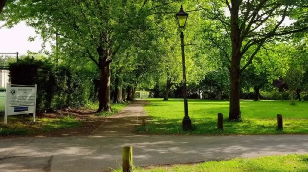
Redland also contains green spaces and recreational facilities. Redland Green is an important open area within the district. The neighbourhood is also close to Bristol’s larger parks and university facilities.
Transport links connect Redland with central Bristol and surrounding districts. The Redland railway station provides access on the Severn Beach Line, linking the area with destinations including Clifton Down, Montpelier, Stapleton Road and Bristol Temple Meads.
Housing varies from smaller flats to substantial Victorian and Edwardian homes. The architectural stock gives the area a strong historic identity.
Redland also has planning protections in parts of the neighbourhood. The Cotham and Redland Conservation Area is subject to specific planning controls, while Bristol City Council maintains an Article 4 Direction covering certain development rights in the area.
What makes Bishopston one of the best suburbs of Bristol?
Bishopston combines established residential streets with Gloucester Road, one of Bristol’s major independent shopping and dining areas. Its location north of the city centre provides access to local businesses, schools, green spaces, transport routes and neighbouring districts such as Redland and Horfield.
Bishopston lies north of central Bristol and is closely associated with Gloucester Road, which runs through Bishopston and neighbouring areas.
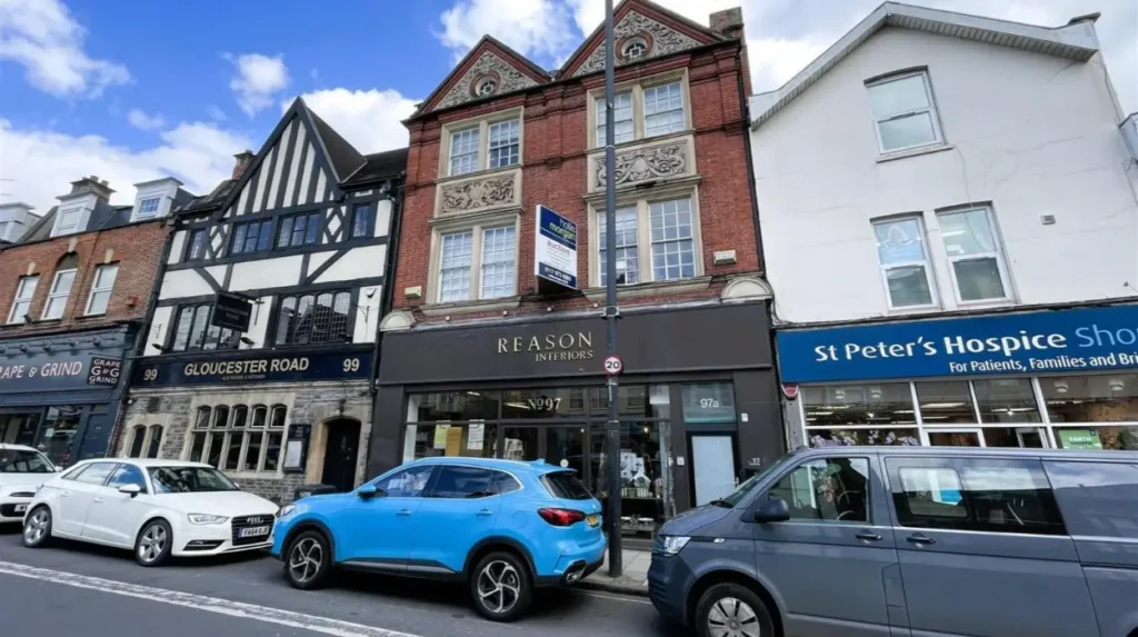
Gloucester Road contains independent shops, cafés, restaurants, pubs and service businesses. This creates a strong local centre within a predominantly residential environment.
Residential streets contain Victorian and Edwardian terraces, smaller houses and converted flats. The housing pattern reflects Bristol’s expansion during the late nineteenth and early twentieth centuries.
Bishopston also benefits from its proximity to Horfield, Redland, Ashley Down and St Andrews. St Andrews Park provides a major green space close to the residential core.
Transport connections include bus services along major roads. Cycling routes also connect Bishopston with central Bristol and neighbouring districts.
Bristol City Council places Bishopston and Ashley Down within Area Committee 2 alongside Redland, Westbury-on-Trym and Henleaze and Stoke Bishop.
The area suits people who want a residential setting without being far from a major urban shopping street.
Why do people choose Henleaze as a Bristol suburb?
Henleaze is an established northern Bristol suburb characterised by residential streets, family housing, green spaces and local shopping. Its position between Westbury-on-Trym, Bishopston and Stoke Bishop provides access to established neighbourhood services while retaining a distinctly suburban environment.
Henleaze sits in north-west Bristol and forms part of a group of established residential districts around Westbury-on-Trym and Stoke Bishop.
The neighbourhood contains substantial Victorian, Edwardian and twentieth-century housing. Detached and semi-detached properties form a significant part of the housing stock.
Bristol City Council’s ward profile for Westbury-on-Trym and Henleaze shows a housing mix that differs from the overall Bristol pattern. The ward contains a higher proportion of detached and semi-detached properties than the Bristol average.
Henleaze also has an established local centre around Henleaze Road, with shops and everyday services.
The area benefits from access to Durdham Downs, one of Bristol’s largest open spaces. The Downs provide walking, recreation and open views across the surrounding city.
Henleaze has a strong planning and architectural identity. Bristol City Council maintains a dedicated character assessment for the area, reflecting the importance of its built form, landscape and historical development.
Its position also provides access to Southmead and major employment and healthcare facilities farther north.
What makes Westbury-on-Trym a desirable Bristol suburb?
Westbury-on-Trym combines historic village character with established residential housing, local shops, green spaces and connections to northern Bristol. The area developed around the River Trym and retains historic buildings alongside later suburban streets, creating a distinctive residential environment.
Westbury-on-Trym is one of Bristol’s best-known suburban villages. Its name comes from its historic relationship with the River Trym.
The historic centre contains older buildings, local shops and community facilities. Later residential development expanded around this core.
The area includes a broad mixture of housing. Period cottages and older properties sit alongside Victorian terraces, semi-detached houses and larger twentieth-century homes.
Westbury Hill, Canford Park and surrounding green areas provide recreational opportunities. The River Trym adds an important geographical feature to the neighbourhood.
The suburb also sits close to Henleaze and Stoke Bishop. This creates access to a wider network of local shops, schools, parks and services.
Westbury-on-Trym and Henleaze form one Bristol City Council ward. The council’s current committee structure places the ward within Area Committee 2.
The area’s village-centre structure distinguishes it from denser inner-city districts. It provides everyday services within a residential environment while remaining within Bristol’s administrative boundary.
Why is Stoke Bishop considered a suburban part of Bristol?
Stoke Bishop is a leafy north-west Bristol suburb with substantial residential properties, access to open spaces, proximity to the University of Bristol’s residential facilities and connections toward Clifton, Westbury-on-Trym and Henleaze. Its low-density housing pattern gives it a distinct suburban identity.
Stoke Bishop occupies elevated ground between Clifton and Westbury-on-Trym. Its position gives the area a strong relationship with Bristol’s western landscape.
The suburb contains larger houses, detached properties, semi-detached homes and institutional buildings. Several streets have substantial gardens and mature trees.
Bristol’s Downs and nearby open spaces provide recreational access. The suburb is also close to Blaise Castle Estate, a major historic park in north-west Bristol.
The University of Bristol has student accommodation and facilities in and around Stoke Bishop. This gives the neighbourhood a connection with the city’s higher education sector.
Transport is primarily road and bus based. Major routes connect Stoke Bishop with Clifton, central Bristol and the northern suburbs.
The area is included within Bristol City Council’s Area Committee 2, together with Redland, Bishopston and Ashley Down, and Westbury-on-Trym and Henleaze.
Housing costs within the area vary according to property size, condition, location and tenure. Citywide figures provide context but do not represent individual streets.
Why is Southville an important residential area in Bristol?
Southville is a residential neighbourhood south of the River Avon and close to central Bristol. It combines Victorian and Edwardian housing with independent businesses, community facilities, walking routes and access to Bedminster, the Harbourside and the city centre.
Southville developed as part of Bristol’s industrial and residential expansion south of the historic centre.
The neighbourhood contains dense terraces, converted properties and modern housing. Its streets reflect different phases of Bristol’s urban development.
Southville’s location provides access to Wapping Wharf, Bristol Harbourside, Ashton Court and the city centre. The River Avon and surrounding waterfront form an important part of the wider landscape.
Local shopping and food businesses are concentrated around North Street, which connects Southville with Bedminster.
Transport links include bus services and walking routes toward central Bristol. The neighbourhood also benefits from cycling infrastructure and pedestrian improvements.
Southville is one of the areas included in Bristol City Council’s South Bristol Liveable Neighbourhood programme. The programme focuses on safer streets, walking, cycling, public spaces and access to local high streets.
Bristol City Council places Southville and Bedminster within Area Committee 7 alongside Windmill Hill and Filwood.
What makes Brislington a practical Bristol suburb?
Brislington is an established east Bristol suburb with a wide range of housing, local services, green spaces and transport connections. Its position along the A4 corridor provides access toward central Bristol, Bath and surrounding communities, while local facilities support everyday residential needs.
Brislington extends along the eastern side of Bristol toward the boundary with South Gloucestershire and Bath and North East Somerset.
The area contains several distinct residential sections. Housing ranges from Victorian terraces and semi-detached homes to twentieth-century estates and newer developments.
The A4 Bath Road is the principal transport corridor. It connects Brislington with central Bristol and the wider route toward Bath.
Brislington also has access to green spaces. Arnos Vale Cemetery, situated near the western side of the area, is a major historic landscape and heritage site.
The neighbourhood contains shopping and services around Brislington Retail Park and local high streets.
Bristol City Council divides Brislington between the Brislington East and Brislington West wards. Both are part of Area Committee 9, alongside Knowle and Stockwood.
The suburb’s location provides a different balance from north-west Bristol. It offers access to eastern and southern parts of the city while retaining a conventional suburban housing structure.
How do Bristol suburbs differ in housing and property types?
Bristol suburbs have substantial differences in housing stock. Clifton and Redland contain many period terraces and converted flats, while Henleaze, Westbury-on-Trym and Stoke Bishop contain more detached and semi-detached homes. Southville and Brislington provide additional mixed suburban housing options.
Housing type is one of the clearest ways to distinguish Bristol’s residential areas.
Clifton contains Georgian and Victorian terraces, villas, flats and converted period properties. Redland has a similar concentration of Victorian and Edwardian buildings.
Bishopston has many terraced homes, particularly around streets close to Gloucester Road.
Henleaze, Westbury-on-Trym and Stoke Bishop contain greater proportions of detached and semi-detached properties. Bristol City Council’s ward profile confirms that Westbury-on-Trym and Henleaze has a higher detached and semi-detached share than Bristol overall.
Southville has a dense terraced housing pattern, while Brislington contains a broader mix of terraces, semi-detached properties, detached homes and modern developments.
Citywide housing figures demonstrate the overall scale of Bristol’s market. In July 2026, the ONS recorded average prices of £689,000 for detached properties, £447,000 for semi-detached properties, £384,000 for terraced properties and £241,000 for flats and maisonettes.
These figures are citywide averages. Individual suburbs and streets have different price levels.
Which Bristol suburbs have the strongest access to green space?
Bristol’s greenest suburban environments include Stoke Bishop, Henleaze, Westbury-on-Trym, Clifton and areas around Southville and Brislington. Major open spaces such as the Downs, Blaise Castle Estate, Clifton Down, St Andrews Park and Arnos Vale support recreation across different parts of the city.
Green space is a major component of Bristol’s residential geography.
The Downs cover a large area between Clifton and Stoke Bishop. The open landscape provides walking, recreation and views across the city.
Blaise Castle Estate in north-west Bristol contains woodland, parkland and historic features. It provides extensive outdoor space near Henleaze and Westbury-on-Trym.
Clifton Down sits within the Clifton and Redland area. Its location provides direct access to open land from dense residential streets.
St Andrews Park serves Bishopston and neighbouring areas. Its landscaped grounds include open lawns, mature trees and recreational areas.
Arnos Vale Cemetery provides historic landscape and green space near Brislington and the southern approach to central Bristol.
Southville connects with the wider waterfront and Ashton area, while Bristol’s Liveable Neighbourhood programme includes public-realm and green-space improvements as part of its planning objectives.
These different green spaces make Bristol’s suburbs varied in landscape as well as housing.
How important is transport when choosing a Bristol suburb?
Transport access differs significantly across Bristol suburbs. Clifton, Redland, Bishopston and Southville sit relatively close to central destinations, while outer suburbs rely more heavily on bus and road corridors. Railway stations also provide important connections from selected neighbourhoods.
Transport should be assessed by destination rather than suburb name alone.
Clifton and Redland provide relatively direct access to central Bristol. Walking, cycling and bus services connect these neighbourhoods with employment, education and cultural destinations.
Redland has a railway station on the Severn Beach Line. This creates a rail connection unavailable in many other Bristol suburbs.
Bishopston benefits from major bus corridors along Gloucester Road and surrounding routes. Southville benefits from its proximity to the city centre and central Bristol’s transport network.
Brislington’s position on the A4 provides a major road connection toward central Bristol and Bath.
Henleaze, Westbury-on-Trym and Stoke Bishop rely heavily on buses and road routes. Their wider roads and lower-density housing reflect their suburban development pattern.
Transport conditions also change through infrastructure projects. Bristol City Council’s Liveable Neighbourhood programme aims to improve walking, cycling, public transport access and local streets in selected areas.
How should visitors and prospective residents compare Bristol suburbs?
A useful Bristol suburb comparison considers location, housing, transport, green space, local services and proximity to employment or attractions. Clifton, Redland, Bishopston, Henleaze, Westbury-on-Trym, Stoke Bishop, Southville and Brislington each provide different combinations of these factors.
The first factor is location. Clifton, Redland and Bishopston sit close to central and north Bristol destinations. Southville provides a similarly convenient position south of the centre.
The second factor is housing. Period terraces dominate several inner suburbs, while detached and semi-detached properties become more common in areas such as Henleaze and Westbury-on-Trym.
The third factor is green space. Stoke Bishop and Henleaze provide access to major open areas. Clifton provides Clifton Down and nearby Downs access. Southville connects with waterfront and southern green spaces.
The fourth factor is local services. Gloucester Road is particularly significant for Bishopston. Henleaze Road and Westbury-on-Trym provide established local centres. Southville has North Street, while Brislington has local centres and larger retail facilities.
The fifth factor is transport. Railway access, bus routes, cycling infrastructure and road connections differ between neighbourhoods.
The sixth factor is housing cost. Bristol’s citywide average house price was £352,000 in July 2026, but this figure does not represent individual suburbs.
How are Bristol’s suburbs changing?
Bristol’s suburbs are changing through housing development, transport improvements, neighbourhood planning and public-space projects. Current changes include Liveable Neighbourhood schemes, planning controls, community-led neighbourhood plans and continuing investment in local infrastructure.
Bristol’s future residential character is influenced by planning policy and neighbourhood-level development.
Bristol City Council currently recognises neighbourhood planning areas including Hengrove and Whitchurch Park, Knowle West, Lawrence Weston, Lockleaze, Old Market and Redcliffe. Neighbourhood plans guide development alongside the city’s Local Plan.
Liveable Neighbourhood projects also influence streets and public spaces. The East Bristol pilot covers parts of Barton Hill, Redfield and St George, while the South Bristol programme covers 11 neighbourhoods.
Planning controls also protect elements of Bristol’s established character. Article 4 Directions apply to selected areas, including parts of Henleaze and the Cotham and Redland Conservation Area.
Housing demand remains an important factor. ONS data recorded a 2.1% annual increase in Bristol’s average house price between July 2025 and July 2026. Average private rent increased 5.9% between August 2025 and August 2026.
These trends mean that Bristol’s suburbs remain dynamic residential environments. Their future development depends on housing supply, transport policy, planning decisions, local investment and changing patterns of work and travel.
Which Bristol suburbs are most suitable for first-time buyers, families and professionals?
Different Bristol suburbs provide different housing and location patterns. First-time buyers often compare flats and terraces in areas such as Bishopston, Southville and Brislington, while families frequently examine Henleaze, Westbury-on-Trym and Stoke Bishop. Professionals often prioritise Clifton, Redland and nearby districts.
First-time buyers typically examine property price, transport and access to daily services. Flats and smaller terraces create more options in inner neighbourhoods.
Bishopston and Southville combine established housing with strong local centres. Brislington provides a wider suburban housing mix.
Families often examine property size, gardens, schools, parks, transport and local services. Henleaze, Westbury-on-Trym and Stoke Bishop contain substantial family housing and access to open spaces.
Professionals often prioritise commuting time and proximity to employment centres. Clifton and Redland sit close to central Bristol, the University of Bristol and major cultural destinations.
These categories are not exclusive. Every suburb contains different property types and household groups.
Bristol’s official deprivation data also demonstrates the importance of looking at smaller neighbourhoods rather than treating an entire suburb as uniform. The 2025 English Indices of Deprivation assess small neighbourhood areas across England and provide Bristol-specific data at neighbourhood level.
Explore More Area Guide
Most Expensive Areas in Bristol: Clifton, BS9 & Redland
Best Affordable Areas in Bristol: Cheapest Places to Live
What are the main alternatives to Bristol’s established suburbs?
Bristol’s established suburbs sit alongside inner-city neighbourhoods, newer developments and communities outside the city boundary. Areas such as Bedminster, Easton, Horfield, Fishponds, Totterdown, Long Ashton and nearby towns provide additional residential choices around the Bristol urban area.
Bristol’s residential geography extends beyond the traditional definition of suburb.
Bedminster and Easton provide denser urban neighbourhoods with strong local centres and direct city connections.
Horfield sits north of the city centre and connects Bishopston with Southmead and Filton.
Fishponds provides an east Bristol residential environment with access to local shopping, parks and cycling routes.
Totterdown is a dense residential district south of the city centre with distinctive terraced housing and elevated streets.
Long Ashton lies outside Bristol’s administrative boundary in North Somerset. It provides a separate suburban and village environment while remaining closely connected to Bristol.
The choice between these areas depends on whether the priority is city-centre proximity, housing space, transport, green space, local shopping or access to neighbouring authorities.
What should you check before choosing one of the best suburbs of Bristol?
Anyone comparing Bristol suburbs should check current property prices, transport routes, local planning policies, parking arrangements, green-space access, property condition and neighbourhood-level data. Citywide averages provide context, but decisions require information about the specific street and property.
Property prices require street-level research because citywide averages conceal substantial differences.
Transport should be checked at the actual property rather than only at neighbourhood level. Walking distance to bus stops, railway stations and main roads affects everyday travel.
Planning restrictions also matter. Conservation areas and Article 4 Directions can affect alterations, extensions, boundary changes and permitted development rights. Bristol City Council provides current planning information for affected areas.
Green space should also be assessed according to the intended use. A nearby park, playing field, woodland or large open space creates different recreational opportunities.
Local services should be checked for the specific part of each suburb. Larger neighbourhoods contain several distinct local centres.
Bristol’s housing market also changes over time. The ONS advises considering longer-term trends because local housing statistics are based on smaller numbers of transactions and can show short-term variation.
The best suburbs of Bristol therefore depend on the combination of housing, transport, green space, services and location that fits a particular purpose. Clifton, Redland, Bishopston, Henleaze, Westbury-on-Trym, Stoke Bishop, Southville and Brislington each represent a distinct part of Bristol’s residential geography.
For visitors, these neighbourhoods provide different ways to experience Bristol beyond the central tourist area. For prospective residents, they offer different housing forms, transport patterns and local environments. Understanding those differences creates a more accurate picture of Bristol than treating the entire city as one residential market.
What are the best suburbs of Bristol?
Clifton, Redland, Bishopston, Henleaze, Westbury-on-Trym, Stoke Bishop, Southville and Brislington are among the established residential areas commonly considered when comparing Bristol suburbs. Each has different housing, transport, green-space and local-amenity characteristics.