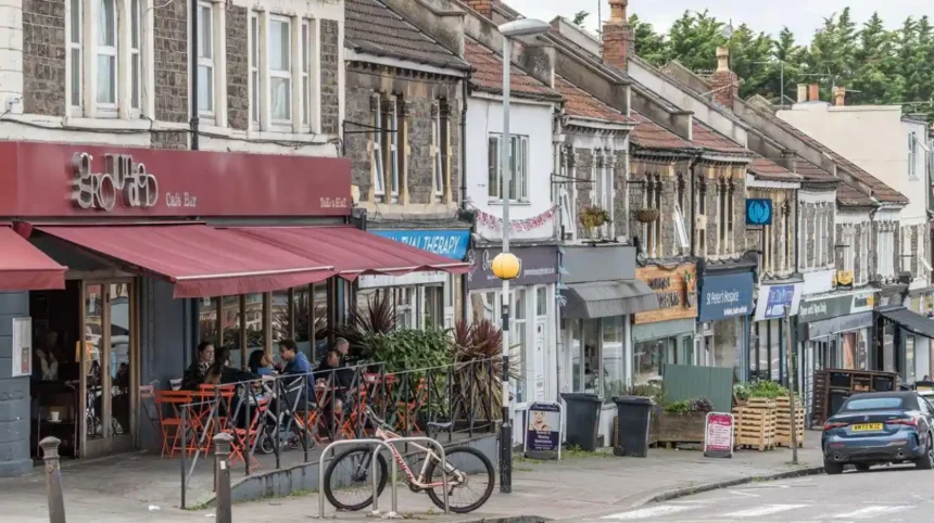
Brislington is a residential area in south-east Bristol, positioned along the historic Bath Road corridor between central Bristol, Knowle, Stockwood, and Keynsham. The area combines established residential streets, historic buildings, conservation areas, parks, nature reserves, local services, employment sites, and major transport routes.
- What is Brislington known for?
- Where is Brislington located in Bristol?
- How did Brislington develop historically?
- What is Brislington House and why is it important?
- What historic buildings can visitors see in Brislington?
- What green spaces and nature reserves are in Brislington?
- What is everyday life like in Brislington?
- How well connected is Brislington to Bristol and Bath?
- What role does Brislington’s conservation area play today?
- What makes Brislington important for visitors?
- How is Brislington likely to remain relevant as Bristol develops?
- Why should Brislington be included in a Bristol area guide?
The area is divided administratively between Brislington East and Brislington West wards. Bristol City Council’s mid-2024 population estimates record 12,385 residents in Brislington East and 12,143 in Brislington West, giving the two wards a combined estimated population of 24,528.
Brislington also has a distinctive historic landscape. Its heritage includes an established village centre, Georgian and Victorian buildings, Brislington House, Church Hill, Brislington Conservation Area, and landscapes associated with the River Avon. The surrounding green infrastructure includes Victory Park, Eastwood Farm and other open spaces.
For visitors, Brislington provides access to Bristol’s south-east districts and the wider Avon Valley. For residents, it functions as an established urban neighbourhood with everyday shops, schools, community facilities, recreation areas and transport connections.
What is Brislington known for?
Brislington is known for its historic village character, Bath Road, Brislington House, green spaces, residential neighbourhoods, Eastwood Farm, local parks and direct transport links between Bristol, Bath and surrounding communities. Its identity combines historic buildings with modern suburban development and commercial activity.
Brislington’s identity is closely connected with the A4 Bath Road, one of the principal routes between Bristol and Bath. The road passes through the area and forms an important transport and commercial corridor.
The historic core is particularly significant. Bristol City Council’s conservation documentation states that the architectural character of the Brislington Conservation Area is strongly associated with Brislington’s status as a village during the 18th century. The conservation area includes Church Hill, Brislington Hill and surrounding historic buildings and spaces.
The neighbourhood also has a substantial natural environment. Eastwood Farm lies in the Avon Valley in south-east Bristol and contains woodland, ponds, open areas and wildlife habitats. The council identifies it as a local nature reserve and a Site of Nature Conservation Interest.
Brislington therefore has several distinct layers. These include the historic village, Bath Road transport corridor, established housing areas, industrial and commercial land, parks, nature reserves and the River Avon landscape.
Where is Brislington located in Bristol?
Brislington is located in south-east Bristol along the Bath Road corridor, east of central Bristol and west of Keynsham. It connects with Knowle, St Anne’s, Stockwood, Broomhill, Brislington Meadows and the Avon Valley through roads, footpaths and local transport routes.
Brislington sits within Bristol’s south-eastern urban area. Its western and north-western connections lead towards St Anne’s, Arnos Vale and the inner city. Stockwood and Knowle lie further south and south-west, while Keynsham is east across the Bristol–Bath corridor.
The River Avon forms an important geographical feature to the north-east and east of the neighbourhood. Eastwood Farm occupies part of the Avon Valley and provides public access to a riverside landscape.
The area’s location has influenced its development. Bath Road created a strong east-west movement corridor, while the surrounding valley, hills and historic farmland shaped settlement patterns.
Brislington is also close to the boundary between Bristol’s built-up urban area and more open landscapes. This produces a mixture of dense residential streets, commercial land, open fields and riverside habitats.
Bristol City Council uses local information systems to map facilities, conservation areas, schools, transport information and other neighbourhood characteristics. Its Know Your Place service also allows users to compare historic maps and investigate how Bristol’s neighbourhoods have changed over time.
How did Brislington develop historically?
Brislington developed from a historic village into an urban Bristol neighbourhood through centuries of agricultural activity, estate development, transport growth and suburban expansion. The 18th century shaped its surviving village character, while later development added housing, industry, roads and public facilities.
Brislington’s historic development is visible in its buildings and street pattern. The conservation area contains historic routes, buildings and spaces associated with the former village.
The 18th century is particularly important to the area’s architectural identity. Bristol City Council’s conservation statement identifies the village status of Brislington during that period as a major influence on the area’s architectural character.
Several surviving buildings demonstrate this heritage. The Old Vicarage on Church Hill is a Grade II listed late-18th-century house. Historic England records its construction in the late 18th century and identifies architectural details including its rendered exterior, sash windows and historic interior features.
Georgian Cottage and Yew Cottage on Hollywood Road are also Grade II listed. Historic England identifies them as a pair of attached late-18th-century cottages constructed from stucco, brick and traditional roofing materials.
West Town House provides another example of surviving historic architecture. Historic England records it as a Grade II listed late-18th and early-19th-century building in West Town Park.
These buildings demonstrate how Brislington retained elements of its earlier village environment while surrounding land was progressively developed.
The later growth of Bristol transformed Brislington’s relationship with the city. Housing expansion, industrial development and improvements to road transport incorporated the former village more closely into the metropolitan area.
Historic mapping remains useful for understanding this process. Bristol’s Know Your Place service provides access to historic maps and heritage information that show how individual neighbourhoods changed over time.
What is Brislington House and why is it important?
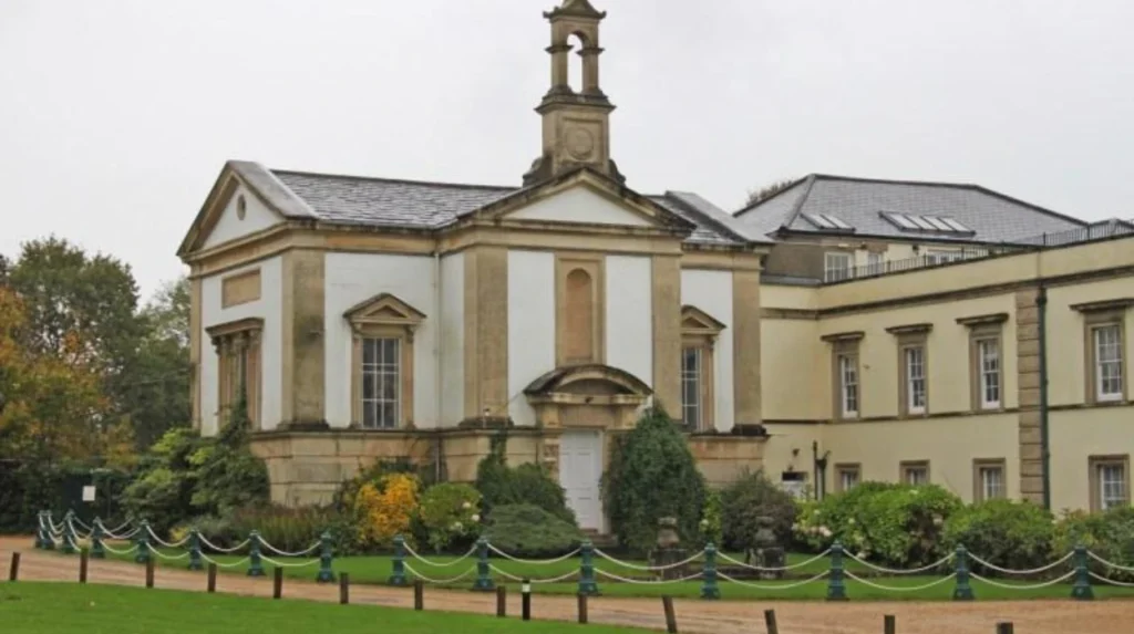
Brislington House is a historic building and landscape on Bath Road associated with Dr Edward Long Fox and a private asylum established in 1804–1806. Its registered park and garden is Grade II, reflecting its national historic importance and influence on therapeutic landscape design.*
Brislington House is one of the area’s most important heritage assets.
Historic England records that Dr Edward Long Fox established the private asylum between 1804 and 1806. Fox was a Bristol physician associated with the Bristol Royal Infirmary. The institution was designed with landscaped grounds connected to the treatment and recreation of patients.
The park and garden associated with Brislington House is registered at Grade II*. Historic England describes the landscape as an early-19th-century garden and pleasure ground and identifies its therapeutic use as historically significant.
The designation reflects the importance of the landscape rather than simply the survival of a historic building. The grounds contained lawns, paths, planting, recreational areas and designed spaces associated with the operation of the institution.
Historic England identifies Brislington House itself as a Grade II listed building, while its registered park and garden has the higher Grade II* designation.
The site also demonstrates how ideas about health, landscape and institutional design developed during the early 19th century. Historic England’s research on institutional landscapes identifies Brislington House as an important example of an asylum landscape where patients’ exercise areas were deliberately designed with ornamental features and views.
The heritage value remains relevant to Brislington’s modern identity. The site forms part of the area’s historic landscape and contributes to the wider heritage character of Bath Road and the surrounding conservation environment.
What historic buildings can visitors see in Brislington?
Visitors can find historic buildings around Brislington’s conservation area and Bath Road, including Brislington House, the Old Vicarage, Georgian Cottage, Yew Cottage and West Town House. These buildings represent architectural development from the 18th and 19th centuries.
Brislington’s historic architecture is concentrated around several streets and estates rather than a single monument.
Church Hill is especially important. The Old Vicarage is a Grade II listed late-18th-century house and forms part of the historic architectural environment around the former village centre.
Hollywood Road contains Georgian Cottage and Yew Cottage. The pair represents domestic architecture from the late 18th century and contributes to the visual character of the conservation area.
West Town House represents another stage in the area’s architectural development. Historic England records its origins in the late 18th and early 19th centuries and identifies its classical architectural details.
Brislington House provides the largest heritage complex. Its associated gardens, listed structures and historical connection with early-19th-century medical practice give it particular importance.
Historic buildings in conservation areas receive additional planning consideration. Bristol currently has 33 conservation areas, which are designated because of special architectural or historic character.
The Planning (Listed Buildings and Conservation Areas) Act 1990 provides the statutory framework for conservation areas in England. Bristol City Council applies conservation policies when considering development proposals that affect these areas.
What green spaces and nature reserves are in Brislington?
Brislington has several significant green spaces, including Victory Park, Eastwood Farm, Callington Road Nature Reserve and nearby open land. These areas provide walking routes, wildlife habitat, play facilities, ecological value and access to the Avon Valley landscape.
Green space is a major part of Brislington’s physical character.
Victory Park is a hillside public park on School Road. Bristol City Council describes it as having a rural feel, open grassland and extensive tree cover. Its facilities include children’s play equipment, seating, paths and accessible areas.
The council’s protected open-space assessment records Victory Park at approximately 5.10 hectares. It identifies health and recreation value as well as ecological value associated with the surrounding Brislington Meadows landscape.
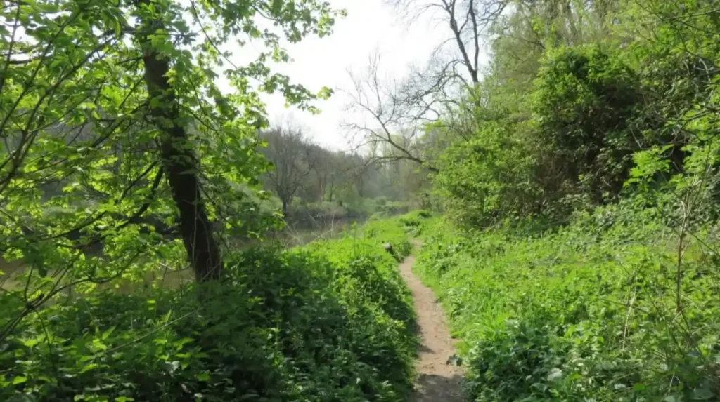
Eastwood Farm is one of Brislington’s most significant natural areas. The site occupies part of the Avon Valley and includes woodland, ponds and wildlife habitats. It is open to the public without an admission charge.
Eastwood Farm has an unusual modern history. It operated as a traditional farm until 1971. Bristol City Council then used the land as a domestic waste landfill between 1971 and 1978. After the landfill closed, the site was landscaped and planted with trees before developing into the nature reserve visible today.
Callington Road Nature Reserve provides another local wildlife area. It includes grassland, wildflowers and a dew pond. The reserve was formally established in 2009 after land was secured and habitat improvements were undertaken.
The range of green spaces means Brislington is not defined only by built development. Its landscape includes parks, woodland, river corridors, nature reserves and protected open space.
What is everyday life like in Brislington?
Everyday life in Brislington combines established residential neighbourhoods with local shops, schools, community facilities, recreation areas, employment sites and transport corridors. The two Brislington wards together had an estimated 24,528 residents in mid-2024, according to Bristol City Council data.
Brislington functions primarily as a residential part of Bristol. Housing ranges from historic properties near the village core to later suburban development and modern housing areas.
The population is distributed across two wards. Brislington East had an estimated 12,385 residents, while Brislington West had 12,143 residents in the mid-2024 estimates published by Bristol City Council.
The same estimates record 0–15-year-old populations of 2,265 in Brislington East and 2,068 in Brislington West. The 25–49 age group accounted for 5,244 residents in Brislington East and 5,193 in Brislington West.
These figures describe the resident population rather than visitor numbers. They also relate to current ward boundaries, so historic population comparisons require care when boundaries change.
Daily amenities are concentrated around the main roads and neighbourhood centres. Bath Road provides a major commercial corridor, while residential streets branch towards parks, schools and community facilities.
The area’s community character is also supported by local groups. Eastwood Farm, for example, has a Friends group that supports conservation activities and community work at the nature reserve.
For residents, the combination of housing, green space and transport makes Brislington a self-contained urban district while retaining strong connections to the wider Bristol area.
How well connected is Brislington to Bristol and Bath?
Brislington has strong road and bus connections through the A4 Bath Road, with regular services linking the area to Bristol city centre, Temple Meads, Keynsham and Bath. Brislington Park & Ride provides an additional public transport connection into Bristol.
Transport is central to Brislington’s location and development.
The A4 Bath Road provides the principal east-west road connection. It links Brislington with central Bristol towards the west and Keynsham and Bath towards the east.
Public transport services operate along the corridor. Travelwest’s current timetable information shows Service 39 connecting Bristol Bus Station, Temple Meads, Brislington Square, Keynsham and Bath.
The X39 also serves the Bristol–Bath corridor, with Brislington Square among its listed stops.
Brislington has a dedicated Park & Ride facility on Bath Road. Travelwest identifies Service 9 as operating between Brislington Park & Ride, Bristol city centre and Portway Park & Ride, with services advertised at intervals of up to every 10 minutes.
The transport network also supports travel beyond Bristol. The Bristol–Bath corridor connects Brislington with Keynsham and Bath without requiring travel through Bristol city centre.
For pedestrians and cyclists, local routes connect residential areas with parks, open spaces and neighbouring districts. Bristol’s planning documents also identify the importance of pedestrian and cycle links around Brislington development sites and Eastwood Farm.
Travel times vary according to traffic, service frequency and destination. Current journey planners should therefore be checked for precise departure information.
What role does Brislington’s conservation area play today?
Brislington Conservation Area protects an important historic village environment containing distinctive buildings, roads, boundaries, open spaces and landscape features. Its designation influences planning decisions and places additional controls on development, alterations and some tree work.
The Brislington Conservation Area is one of Bristol’s designated heritage areas. Bristol City Council’s conservation documentation describes its boundaries and architectural characteristics in detail.
The conservation area includes historic elements around Church Hill, Brislington Hill, Hollywood Road, Victory Park and adjoining areas. Its character derives from the relationship between buildings, roads, gardens, boundaries, open spaces and topography.
Conservation-area designation does not prevent development. It ensures that the historic character of an area receives specific consideration during planning decisions.
Bristol City Council states that conservation areas have stricter planning controls than other areas. Major work within a conservation area requires appropriate planning consideration, while some tree works require formal notice.
Trees within conservation areas also receive protection. Bristol City Council states that trees with a trunk diameter of 75mm or more measured at 1.5 metres above ground level are protected within conservation areas, subject to the relevant rules and exemptions.
This planning framework helps retain the physical characteristics that distinguish Brislington’s historic core from later suburban development.
What makes Brislington important for visitors?
Brislington gives visitors access to historic architecture, conservation areas, parks, nature reserves, riverside landscapes and transport links along the Bristol–Bath corridor. It works particularly well as part of a wider south-east Bristol itinerary rather than as a single concentrated attraction district.
Visitors interested in local history can explore the area’s historic streets and listed buildings, particularly around Church Hill and the Brislington Conservation Area.
Brislington House provides a major heritage reference point, although access to historic properties and private grounds depends on current ownership and arrangements. Historic England records that most listed heritage sites are not automatically open to the public.
For outdoor activities, Victory Park provides open grassland, trees and play facilities. Eastwood Farm provides a different landscape with woodland, ponds, wildlife and access to the Avon Valley.
The area also provides a practical base for exploring other parts of Bristol. Its Bath Road position gives visitors access to central Bristol, the Avon Valley, Keynsham and Bath through the wider transport network.
Brislington’s heritage can also be researched remotely. Bristol Archives holds historical photographs, maps, documents and other material relating to Bristol and surrounding areas. Its searchroom provides public access to archival collections.
Explore More Area Guide
Fishponds Area Guide: History, Parks, Food and Transport
Horfield Area Guide: History, Homes, Parks and Local Life
How is Brislington likely to remain relevant as Bristol develops?
Brislington’s future relevance is closely connected with housing, transport, heritage protection, green infrastructure, ecological conservation and the wider growth of Bristol. Planning policy continues to balance development needs with historic landscapes, open space, transport capacity and environmental constraints.
Brislington remains part of a growing Bristol urban area. Bristol City Council estimates the city’s mid-2025 population at 495,300, with an estimated increase of 43,500 residents between 2015 and 2025.
Growth creates continuing demand for housing, transport infrastructure, public services and green space.
Brislington’s planning context therefore includes both development opportunities and environmental constraints. Council planning documents identify the importance of pedestrian and cycle connections, transport improvements, green infrastructure and protection of environmental assets in development areas.
Flood risk is also relevant to the Avon Valley. Bristol’s Strategic Flood Risk Assessment identifies the River Avon at Eastwood Farm Open Space and Brislington Brook at Nightingale Valley within areas identified as functional floodplain.
This information is important for understanding future land-use planning. Riverside and low-lying areas require specific flood-risk assessment when development proposals are considered.
Heritage protection is another long-term factor. Brislington House’s Grade II* registered park and garden, the conservation area and numerous listed buildings place historic character at the centre of planning considerations.
The result is a neighbourhood where future development takes place alongside established heritage and environmental assets.
Why should Brislington be included in a Bristol area guide?
Brislington represents an important part of south-east Bristol because it combines historic village character, substantial residential communities, Bath Road transport connections, protected heritage, public parks, nature reserves and Avon Valley landscapes within one established urban neighbourhood.
The area has a clear geographical role within Bristol. It connects the city with Keynsham and Bath while providing residential communities between central Bristol and the eastern edge of the metropolitan area.
Its historical importance is visible through the Brislington Conservation Area, listed buildings and Brislington House. Its environmental importance is represented by Eastwood Farm, Victory Park, Callington Road Nature Reserve and the wider Avon Valley.
Its demographic importance is reflected in the estimated 24,528 residents across Brislington East and Brislington West in mid-2024.
Its transport role is demonstrated by the A4 Bath Road, Bristol–Bath bus services and Brislington Park & Ride.
For visitors, Brislington offers a combination of heritage and outdoor locations. For residents, it provides an established neighbourhood with everyday services and connections to Bristol’s wider employment, education and cultural centres.
Its defining feature is therefore its combination of history, housing, transport, green infrastructure and local community life. These characteristics explain Brislington’s continuing role within Bristol and provide the foundation for understanding the area as it develops.
What is Brislington known for?
Brislington is known for its historic village character, Bath Road, Brislington House, Brislington Conservation Area, Eastwood Farm, Victory Park, local amenities and transport connections between Bristol, Keynsham and Bath.