Bristol’s historic streets reveal the city’s development as one of England’s most important maritime, trading, industrial and cultural centres. From the medieval lanes surrounding the Old City to the Georgian terraces of Clifton and the historic waterfront approaches, Bristol’s streets preserve evidence of centuries of economic growth, architectural change and social transformation.
- What Makes Bristol’s Historic Streets Important to the City’s Heritage?
- How Did Bristol’s Medieval Streets Develop?
- Which streets preserve Bristol’s medieval layout?
- What remains of Bristol’s medieval city walls?
- How did medieval trade influence street development?
- Which Historic Streets Should Visitors Explore in Bristol?
- How Did Bristol’s Georgian Streets Change the City?
- What architectural features identify Georgian streets?
- Why is Clifton important to Bristol’s historic street network?
- How did maritime wealth influence Georgian architecture?
- What Can Visitors Discover Along Bristol’s Historic Harbourside Streets?
- Which historic waterfront streets are worth exploring?
- How did the Floating Harbour influence Bristol’s streets?
- Which Historic Neighbourhood Streets Reveal Bristol’s Industrial and Social History?
- What makes Stokes Croft historically significant?
- Why is Old Market important to Bristol’s history?
- What does Redcliffe reveal about Bristol’s maritime past?
- How do Bedminster’s historic streets reflect industrial development?
- How Do Bristol’s Historic Buildings and Street Materials Reflect Different Periods?
- Which building materials are common in historic Bristol?
- How can visitors recognise medieval, Georgian and Victorian architecture?
- Why are historic street layouts important?
- How Does Bristol Protect Its Historic Streets and Buildings?
- How many conservation areas does Bristol have?
- What protection do listed buildings receive?
- How can visitors research the history of individual streets?
- How Can Visitors Explore Bristol’s Historic Streets on Foot?
- Why Do Bristol’s Historic Streets Remain Important Today?
- How do historic streets support Bristol’s tourism economy?
- How do historic streets support independent businesses?
- Why is heritage conservation important for future development?
- Why Should Bristol’s Historic Streets Be Preserved?
The city’s historic street network connects important landmarks, including Bristol Cathedral, St Nicholas Market, Christmas Steps, King Street and Clifton Village. These locations demonstrate how medieval commerce, maritime activity, Georgian prosperity and modern regeneration shaped the city’s urban landscape.
Understanding Bristol’s historic streets requires examining their origins, architectural features, commercial functions and connections with the wider history of the city. They remain important public spaces for residents, visitors, independent businesses and heritage organisations.
What Makes Bristol’s Historic Streets Important to the City’s Heritage?
Bristol’s historic streets are important because they preserve evidence of the city’s medieval development, maritime economy, Georgian expansion and industrial growth. Their street layouts, historic buildings, markets and public spaces demonstrate how trade, transport, religion and residential development shaped Bristol over several centuries.
Bristol developed around the River Avon and River Frome, where waterways supported transport, commerce and settlement. Its geographical position connected inland England with international maritime trading routes. The city’s street network expanded around its commercial centre, harbour, religious buildings and residential districts.
During the medieval period, Bristol became an established trading settlement. Merchants, craftspeople and market traders occupied streets close to the harbour and central marketplaces. Narrow lanes connected commercial buildings with churches, warehouses and residential properties.
The medieval street pattern remains visible in parts of the Old City. Buildings and street names provide evidence of historic occupations, commercial activities and local institutions.
The development of Bristol continued during the 17th and 18th centuries. Maritime trade increased commercial wealth, supporting the construction of substantial merchant houses, churches, public buildings and Georgian residential streets.
Bristol’s historic streets also reflect difficult aspects of its past. The city’s prosperity was connected with the transatlantic slave trade, which involved the forced transportation and exploitation of enslaved Africans. Historic buildings and commercial districts therefore provide opportunities to examine both economic development and the human consequences of maritime commerce.
Today, conservation areas, listed buildings and heritage initiatives protect important parts of Bristol’s historic environment. These protections help maintain the architectural character of historic streets while accommodating modern businesses, housing and public activity.
How Did Bristol’s Medieval Streets Develop?
Bristol’s medieval streets developed around its early settlement, defensive walls, river crossings and trading centre. High Street, Corn Street, Broad Street and Wine Street formed important parts of the historic urban layout, connecting merchants, markets, churches and residential properties.
Bristol’s origins date to approximately 1000 AD. The settlement developed from an Anglo-Saxon community known as Brycgstow, meaning a place at the bridge. Its location near the River Avon supported trade and movement between inland settlements and coastal destinations.
By 1051, Bristol was recorded as an established port trading with Ireland, Somerset and North Devon. Wool and leather were among its important exports. These commercial activities encouraged the development of permanent streets, markets and storage facilities.
Following the Norman Conquest in 1066, Bristol developed additional defensive infrastructure. A castle was established, and stone city walls strengthened the settlement’s protection. The walls influenced the direction of streets, the location of gateways and the boundaries of commercial properties.
Which streets preserve Bristol’s medieval layout?
The historic Old City retains important sections of the medieval street pattern.
- High Street: A central historic route connecting the old commercial district with Bristol Bridge.
- Corn Street: An important medieval trading street associated with Bristol’s historic marketplace.
- Broad Street: A historic thoroughfare that formed part of the original walled city’s main street network.
- Wine Street: A central commercial street associated with the medieval settlement.
- St Nicholas Street: A historic route close to the former city defences and St Nicholas Church.
The medieval city’s main crossroads developed around the High Cross, where Corn Street and High Street meet. This location became an important reference point for Bristol’s commercial and civic geography. The Old City heritage organisation identifies these streets and their surrounding lanes as surviving evidence of the medieval urban layout.
What remains of Bristol’s medieval city walls?
Sections of Bristol’s medieval defences survive around St John’s Gate and the Church of St John the Baptist. The historic gateway provides evidence of how defensive walls influenced movement into the medieval city.
The walls originally included several fortified entrances. These controlled access between the settlement and surrounding areas. As Bristol expanded, sections of the defensive structures were demolished to accommodate new streets and buildings.
The surviving remains are important because they connect modern streets with the city’s original defensive boundaries.
How did medieval trade influence street development?
Commercial activity influenced the location and structure of Bristol’s streets. Merchants required accessible routes between the harbour, marketplaces, warehouses and residential properties.
Market streets developed around businesses selling food, textiles, leather and other commodities. Workshops and storage buildings occupied nearby plots. Narrow lanes provided connections between larger commercial thoroughfares.
This historic relationship between transport, markets and property development remains visible in the Old City.
Which Historic Streets Should Visitors Explore in Bristol?
Bristol’s most recognisable historic streets include Christmas Steps, King Street, Corn Street, High Street, Broad Street, Park Street and Queen Square. Each location represents a different period of urban development, from medieval trading routes to Georgian residential and commercial architecture.
The historic streets of Bristol are distributed across the Old City, Harbourside, central commercial district and western neighbourhoods. Their architectural character reflects different construction periods and economic activities.
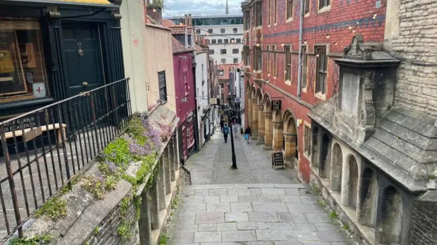
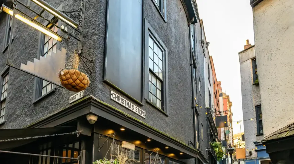
Christmas Steps
Christmas Steps is one of Bristol’s most distinctive historic pedestrian streets. It connects the upper city-centre area with the streets below St Michael’s Hill.
The steps received improvements in September 1669, funded by Jonathan Blackwell, a Bristol wine merchant and sheriff. An inscription records the completion of this work.
The historic route contains steep stone steps, cobbled surfaces, older buildings and traditional street features. Historic England identifies buildings at numbers 6 and 7 as part of one of Bristol’s best-surviving medieval street environments, although those particular properties date from the 17th century.
The surrounding buildings include evidence of earlier timber-framed construction behind later façades. The street also contains Foster’s Almshouses, a historic charitable residential development.
Today, Christmas Steps connects heritage architecture with independent retail. Specialist shops, galleries and traditional businesses contribute to its commercial character.
King Street
King Street is a historic street near Bristol’s Harbourside, recognised for its Georgian architecture and cultural buildings.
The street developed into an important commercial and entertainment location. Its historic buildings reflect the growth of Bristol’s maritime economy and the expansion of its prosperous merchant population.
The Bristol Old Vic is one of its most important cultural landmarks. Founded in 1766 as the Theatre Royal, it is recognised as the oldest continuously working theatre in the English-speaking world.
King Street also contains traditional public houses and historic commercial properties. Its proximity to the harbour connects the street with Bristol’s maritime trading history.
The street’s combination of Georgian architecture, theatre heritage and hospitality businesses makes it an important part of central Bristol’s historic environment.
Corn Street
Corn Street formed part of medieval Bristol’s commercial centre. Its historic marketplace connected merchants, buyers and sellers operating within the walled city.
One of its most important buildings is the Corn Exchange. Built in the 18th century, it reflects the importance of organised trade in Bristol’s expanding economy.
The Exchange is particularly recognisable for its clock, which displays two sets of minutes. The additional minutes indicate Bristol local time, historically measured according to the position of the sun, alongside Greenwich Mean Time.
The nearby St Nicholas Market occupies the former Corn Exchange complex and remains an important retail destination.
The street demonstrates how medieval commercial spaces evolved into more formal trading and civic environments during the Georgian period.
High Street and Broad Street
High Street and Broad Street preserve important parts of Bristol’s historic central street network.
High Street connects the old commercial centre with Bristol Bridge and nearby historic buildings. Its position reflects the importance of the river crossing in the development of the early settlement.
Broad Street contains historic commercial and civic architecture. Its buildings demonstrate how Bristol’s commercial centre expanded and changed as the city became an increasingly important regional trading destination.
Both streets are useful for understanding the original structure of medieval Bristol because their alignment reflects the historic street network.
Park Street
Park Street is a prominent historic street connecting central Bristol with the higher ground around Brandon Hill and Clifton.
Its steep gradient reflects Bristol’s distinctive topography. The street developed into an important commercial and residential route, particularly during the city’s Georgian expansion.
Park Street contains historic townhouses, retail premises and architectural features associated with the 18th and 19th centuries.
At the upper end, visitors can access Brandon Hill and Cabot Tower, completed in 1897 to commemorate the 400th anniversary of John Cabot’s voyage to North America.
Park Street therefore connects historic shopping activity with public heritage and recreational space.
Queen Square
Queen Square is a Georgian public square surrounded by historic buildings and landscaped open space.
Its development reflects the expansion of Bristol’s prosperous residential districts during the 18th century. The square provided an organised urban setting for substantial townhouses and commercial properties.
The central green space distinguishes Queen Square from the narrower medieval streets of the Old City. Its layout demonstrates the influence of formal Georgian town planning.
The square also has an important political history. It became the location of the Bristol Riots of 1831, following opposition to the parliamentary Reform Bill and the political events surrounding its passage through the city.
Today, Queen Square remains an important public space for walking, events and access to Bristol’s historic waterfront district.
How Did Bristol’s Georgian Streets Change the City?
Bristol’s Georgian streets developed during the 18th and early 19th centuries as maritime commerce, merchant wealth and population growth increased demand for housing and commercial buildings. Queen Square, Park Street, Clifton and surrounding districts demonstrate this architectural and urban transformation.
The Georgian period traditionally covers the reigns of the first four British monarchs named George, from 1714 to 1830. In Bristol, this period brought significant changes to residential architecture, commercial development and public spaces.
The city’s expanding maritime economy supported the construction of larger properties. Wealthy merchants and professionals commissioned townhouses with symmetrical façades, sash windows, decorative doorways and classical architectural details.
These buildings contrasted with the narrower medieval plots and older street arrangements of the central Old City.
What architectural features identify Georgian streets?
Georgian architecture is associated with proportion, symmetry and classical design.
Common features include:
- Sash windows: Vertically sliding window frames used in Georgian residential buildings.
- Symmetrical façades: Balanced arrangements of doors, windows and architectural details.
- Decorative entrances: Fanlights, columns and moulded door surrounds.
- Rendered elevations: Smooth external finishes used on many Georgian townhouses.
- Terraced development: Connected houses constructed in consistent architectural styles.
Bristol’s historic streets contain several examples of these characteristics. The architecture of Clifton, Queen Square and Park Street demonstrates how Georgian design influenced the city’s appearance.
Why is Clifton important to Bristol’s historic street network?
Clifton developed as an important residential district during Bristol’s Georgian expansion.
Its streets contain substantial townhouses, terraces and crescents built on elevated ground west of the city centre. The area’s architectural character reflects the demand for prestigious residential properties during the 18th and 19th centuries.
Royal York Crescent is a particularly prominent example. Its curved arrangement of Georgian townhouses demonstrates the scale and ambition of Bristol’s historic residential development.
Clifton Village also contains independent shops, historic public houses and streets with distinctive architectural details.
How did maritime wealth influence Georgian architecture?
Bristol’s maritime trade contributed to the growth of merchant wealth and demand for substantial residential properties.
However, this prosperity was closely connected with Britain’s colonial economy and the transatlantic slave trade. Bristol merchants, shipowners and financial interests participated in the trafficking and exploitation of enslaved Africans.
The city’s historic architecture must therefore be understood within this wider economic and social context. Georgian buildings reflect both architectural development and the unequal economic systems that helped finance parts of the city’s expansion.
The Georgian House Museum provides information about domestic life, household structures and the relationship between Bristol’s Georgian prosperity and slavery.
What Can Visitors Discover Along Bristol’s Historic Harbourside Streets?
Bristol’s Harbourside streets preserve the city’s maritime and industrial heritage through former warehouses, dockside buildings, historic engineering structures and converted commercial properties. These streets explain how shipping, shipbuilding and international trade influenced Bristol’s economy, architecture and urban development.
Bristol’s waterfront developed around the River Avon and River Frome. These waterways supported commercial transport and connected the city with national and international trading networks.
The historic harbour became a major centre for importing and exporting goods. Warehouses, merchant offices, shipbuilding facilities and trading premises developed along the waterfront.
The creation of Bristol’s Floating Harbour in 1809 transformed the city’s dock system. The engineering project maintained a more consistent water level, helping ships remain afloat despite changes in the River Avon caused by tides.
Which historic waterfront streets are worth exploring?
Welsh Back is a historic waterfront street associated with Bristol’s commercial shipping activities. Its location beside the Floating Harbour reflects the relationship between streets, warehouses and maritime transport.
King Street connects the waterfront with Bristol’s Georgian commercial and entertainment heritage. Its historic buildings and theatre provide evidence of the city’s cultural development.
Narrow Quay offers access to the central harbour area and historic dockside environment. Its location connects visitors with the city’s maritime attractions.
Queen Square provides a formal Georgian public space close to the waterfront. Its architecture demonstrates the relationship between commercial prosperity and residential planning.
How did the Floating Harbour influence Bristol’s streets?
The Floating Harbour changed how Bristol managed maritime transport. Before its construction, tidal changes affected the movement and handling of ships.
The harbour engineering system created more stable water levels within the docks. This supported the continued operation of warehouses, shipyards and other maritime businesses.
The development also influenced surrounding streets. Commercial premises expanded around dock entrances, quays and transport connections.
Today, former industrial buildings have been adapted for museums, restaurants, offices and cultural venues.
The M Shed occupies a former transit shed and presents Bristol’s social, industrial and maritime history. Nearby, Underfall Yard preserves important dock engineering facilities.
These locations demonstrate how historic waterfront infrastructure continues to shape Bristol’s modern urban environment.
Which Historic Neighbourhood Streets Reveal Bristol’s Industrial and Social History?
Bristol’s historic neighbourhood streets reveal the city’s industrial expansion, working-class communities, commercial activity and changing social structure. Stokes Croft, Old Market, Redcliffe and Bedminster contain buildings and street patterns associated with manufacturing, housing, trade and community development.
Bristol’s historic character extends beyond its medieval centre and Georgian residential districts. Several neighbourhoods preserve evidence of the industries and communities that supported the city’s expansion.
Their buildings reflect changing employment patterns, transport systems, housing requirements and local commercial activity.
What makes Stokes Croft historically significant?
Stokes Croft is a historic northern approach to central Bristol.
The area developed around important transport and commercial connections. Its buildings reflect different periods of urban growth, including traditional shops, former industrial properties and residential buildings.
Stokes Croft is also associated with Bristol’s independent cultural and creative industries. Street art, music venues, community organisations and independent retailers contribute to its contemporary identity.
Its architectural character combines older commercial buildings with later adaptations. This makes the neighbourhood relevant to understanding how historic streets accommodate changing cultural and economic uses.
Why is Old Market important to Bristol’s history?
Old Market is an established district east of Bristol’s historic city centre.
Its position near the former city entrances made it an important location for trade, transport and commercial movement. The area developed as Bristol expanded beyond its medieval boundaries.
Old Market contains historic commercial buildings, traditional public houses and properties associated with earlier manufacturing and retail activity.
Its built environment demonstrates the transition from an enclosed medieval settlement towards a larger industrial and commercial city.
The district also provides evidence of Bristol’s changing residential population and local business economy.
What does Redcliffe reveal about Bristol’s maritime past?
Redcliffe is a historic district south of Bristol’s central harbour.
The area developed around important commercial routes and maritime connections. Its location near the River Avon supported trade, manufacturing and industrial activity.
The most prominent landmark is St Mary Redcliffe Church. This major medieval church is recognised for its Gothic architecture and long association with Bristol’s religious and civic history.
Redcliffe’s streets also contain industrial buildings, historic warehouses and properties reflecting different phases of urban development.
The district is particularly important for understanding the relationship between religious institutions, commercial activity and the city’s waterfront economy.
How do Bedminster’s historic streets reflect industrial development?
Bedminster developed as an important industrial and residential district south of the River Avon.
Its expansion was connected with manufacturing, transport and population growth during the industrial period.
North Street remains an important local commercial route. Its buildings reflect the development of neighbourhood retail, traditional businesses and residential properties.
Bedminster’s historic environment also demonstrates how industrial districts developed their own commercial centres rather than depending entirely on Bristol’s central marketplace.
How Do Bristol’s Historic Buildings and Street Materials Reflect Different Periods?
Bristol’s historic streets contain medieval stonework, Georgian townhouses, Victorian commercial buildings and converted industrial properties. Building materials, window designs, roof structures, street surfaces and property layouts help identify the historical periods and functions of individual streets.
The architectural appearance of Bristol changes across its historic districts. This reflects different construction technologies, economic conditions and planning requirements.
Which building materials are common in historic Bristol?
Local geology influenced Bristol’s historic construction materials.
Bath stone became particularly important in prestigious buildings and Georgian architecture. This limestone is associated with elegant façades, decorative details and formal residential properties.
Pennant sandstone also appears in Bristol’s historic built environment. Its local availability made it suitable for construction, paving and boundary walls.
Brick became increasingly common during later periods of urban expansion. Victorian commercial and residential buildings frequently used brickwork alongside stone detailing.
Timber-framed construction also survives in some older buildings, although later façades conceal parts of the original structures.
How can visitors recognise medieval, Georgian and Victorian architecture?
Medieval architecture
Narrow plots, historic stonework, timber framing, irregular façades and evidence of older street layouts characterise surviving medieval environments.
Georgian architecture
Symmetrical façades, sash windows, classical doorways and consistent terraced buildings identify many Georgian streets.
Victorian architecture
Decorative brickwork, larger commercial premises, elaborate window details and varied rooflines identify many Victorian developments.
Why are historic street layouts important?
Street layouts provide evidence of how cities developed.
Medieval streets often follow older property boundaries and historic routes. Georgian developments frequently feature planned squares, terraces and more regular building arrangements.
Industrial expansion introduced wider transport routes, commercial frontages and new residential streets.
These differences help historians understand the relationship between architecture, transport and economic development.
How Does Bristol Protect Its Historic Streets and Buildings?
Bristol protects its historic streets through conservation areas, listed building legislation, planning policies and heritage assessments. Bristol City Council uses these measures to preserve significant architecture, historic street patterns, traditional materials, public spaces and distinctive neighbourhood character.
Heritage protection is essential because historic streets face pressure from redevelopment, building alterations, transport changes and commercial expansion.
Bristol City Council manages the city’s historic environment through planning and conservation policies.
How many conservation areas does Bristol have?
Bristol City Council’s conservation information identifies 33 conservation areas. These include the City and Queen Square, Clifton and Hotwells, Old Market, Redcliffe, Park Street and Brandon Hill, Stokes Croft and St Michael’s Hill and Christmas Steps.
A conservation area is a designated location with special architectural or historic interest. Its character and appearance receive additional consideration during planning decisions.
Conservation assessments examine features such as:
- Historic road patterns and property boundaries.
- Traditional building materials and construction methods.
- Historic building uses and architectural styles.
- Trees, green spaces and street furniture.
- Important public views and urban landscapes.
These features demonstrate that conservation involves protecting the wider character of streets, not simply individual buildings.
What protection do listed buildings receive?
A listed building is a property recognised for its special architectural or historic interest and national importance.
Historic England recommends buildings for designation, while the Secretary of State for the Department for Culture, Media and Sport makes listing decisions.
Listed buildings receive legal protection under the Planning (Listed Buildings and Conservation Areas) Act 1990.
Owners generally require listed building consent for alterations that affect a building’s special architectural or historic character. This includes relevant changes to internal and external features.
Bristol City Council provides guidance for owners, developers and planning professionals undertaking work on historic properties.
How can visitors research the history of individual streets?
Know Your Place is a digital heritage resource that allows people to explore historic maps, photographs and geographical information.
Visitors and researchers can use historical mapping to compare older street layouts with modern development.
Bristol’s Historic Environment Record also contains information about archaeological sites, historic buildings and other heritage assets.
These resources help explain how individual streets changed over time and why particular buildings or spaces receive protection.
How Can Visitors Explore Bristol’s Historic Streets on Foot?
Visitors can explore Bristol’s historic streets through a self-guided walking route connecting the Old City, Christmas Steps, King Street, Corn Street, Queen Square and the Harbourside. This route combines medieval heritage, Georgian architecture, maritime landmarks and historic commercial buildings.
Walking is an effective way to understand Bristol’s historic street network because many important landmarks are located close together.
A central walking route allows visitors to compare architectural periods while discovering the city’s commercial and cultural history.
1. Begin at Corn Street
Start in the Old City and explore the historic commercial centre. Examine the Corn Exchange and surrounding buildings to understand Bristol’s trading history.
2. Visit St Nicholas Market
Explore the historic market building and its surrounding commercial streets. The market connects Bristol’s traditional retail heritage with its modern independent business community.
3. Continue towards Christmas Steps
Walk towards Christmas Steps to discover historic stone paving, narrow pedestrian routes and older buildings. The steep steps provide evidence of Bristol’s historic topography.
4. Explore Park Street
Continue towards Park Street to examine Georgian and Victorian architecture. The uphill route also provides access to Brandon Hill.
5. Visit Queen Square
Walk towards Queen Square to discover Georgian town planning and the history of Bristol’s political development.
6. Continue along King Street
Explore the historic theatre, Georgian buildings and traditional hospitality businesses.
7. Finish at Welsh Back
Complete the route along the waterfront to discover the relationship between historic commercial streets and Bristol’s maritime economy.
The route provides opportunities for photography, heritage research, shopping and visits to historic attractions. Visitors should allow additional time for museums, markets and architectural stops.
What should visitors consider when exploring historic streets?
Bristol’s historic centre contains steep streets, uneven paving and pedestrian steps. Comfortable walking shoes are useful, particularly around Christmas Steps and Park Street.
Visitors should also consider accessibility. Christmas Steps contains significant gradients and stairs, making it unsuitable for some wheelchair users and people with limited mobility. Alternative routes through flatter central streets provide access to other historic locations.
Public transport connects Bristol’s central districts with neighbourhoods such as Clifton, Redcliffe and Bedminster.
Explore More Area Guide
Historic Buildings in Bristol: Medieval, Georgian and Victorian Landmarks
Bristol History Guide: From Roman Settlement to Modern City
Why Do Bristol’s Historic Streets Remain Important Today?
Bristol’s historic streets remain important because they support tourism, independent retail, cultural activity, local identity and heritage conservation. Their continued use connects the city’s historic architecture with modern businesses, public spaces, residential communities and sustainable urban development.
Historic streets are not simply preserved architectural environments. They remain functional parts of Bristol’s economy and everyday urban life.
Their commercial buildings accommodate shops, restaurants, offices, galleries and cultural organisations. Public spaces support community activities and events.
How do historic streets support Bristol’s tourism economy?
Bristol attracts visitors interested in maritime history, architecture, museums, shopping and cultural attractions.
Historic streets connect these activities within an accessible urban environment.
Christmas Steps attracts visitors interested in traditional architecture and independent retail. King Street combines historic buildings with theatre and hospitality. Corn Street connects visitors with the Old City and St Nicholas Market.
These locations encourage visitors to explore beyond individual attractions and discover the surrounding neighbourhoods.
How do historic streets support independent businesses?
Historic commercial buildings provide premises for independent retailers, specialist shops, cafés and creative businesses.
Their traditional layouts contribute to the character of local shopping districts. Independent businesses also maintain commercial activity in older neighbourhoods.
Stokes Croft and Christmas Steps demonstrate how heritage environments accommodate contemporary retail and creative industries.
However, maintaining historic buildings requires careful investment. Property owners must balance modern facilities, accessibility, energy efficiency and conservation requirements.
Why is heritage conservation important for future development?
Bristol’s historic streets face continued pressure from housing demand, transport improvements, commercial redevelopment and changing property requirements.
Conservation policies help manage these changes while protecting significant architectural and historic features.
Sensitive building restoration, adaptive reuse and appropriate public-space improvements allow historic properties to remain useful.
The future of Bristol’s historic streets depends on maintaining this relationship between preservation and practical urban development.
Why Should Bristol’s Historic Streets Be Preserved?
Bristol’s historic streets provide a detailed record of the city’s development from an early medieval trading settlement into a major maritime, industrial and cultural centre.
Corn Street and High Street preserve elements of the medieval commercial network. Christmas Steps demonstrates the survival of historic pedestrian routes. King Street and Queen Square reveal the influence of Georgian prosperity, while Park Street and Clifton illustrate the expansion of prestigious residential and commercial architecture.
The Harbourside connects these historic districts with Bristol’s maritime economy, while neighbourhoods such as Redcliffe, Old Market, Bedminster and Stokes Croft reveal the city’s industrial and social development.
Conservation areas, listed building protections and historic mapping resources help safeguard this architectural inheritance.
For residents, visitors and researchers, Bristol’s historic streets provide opportunities to understand local history through buildings, public spaces and surviving urban layouts. Their preservation ensures that the city’s architectural identity and historical significance remain visible as Bristol continues to develop.
What are the most historic streets in Bristol?
Some of Bristol’s most historic streets include Christmas Steps, King Street, Corn Street, High Street, Broad Street and Welsh Back. These streets preserve medieval layouts, Georgian buildings and evidence of the city’s maritime trading history.