Totterdown is a distinctive inner-city neighbourhood in south Bristol, known for steep streets, colourful Victorian and Edwardian terraces, views across Bristol, independent food and drink venues, and proximity to Bristol Temple Meads. It sits between central Bristol, Bedminster, Windmill Hill, Knowle and the River Avon corridor.
- What is Totterdown and where is it?
- How did Totterdown develop historically?
- Why is Totterdown known for its steep streets and colourful houses?
- What types of homes are found in Totterdown?
- What is everyday life like in Totterdown?
- What food and drink can you find in Totterdown?
- What can visitors do in Totterdown?
- How close is Totterdown to Bristol Temple Meads?
- How accessible is Totterdown by bus, walking and cycling?
- What green spaces are near Totterdown?
- Does Totterdown have important heritage sites?
- How is Totterdown changing?
- Why is Totterdown important within Bristol?
The neighbourhood combines residential streets with local businesses, green spaces and important transport connections. Its elevated position gives Totterdown a strong visual relationship with Bristol city centre and the surrounding southern suburbs. VisitBristol identifies Totterdown alongside Bedminster and Southville as part of a lively area south of the river with independent businesses, restaurants, bars, parks and cultural attractions.
Totterdown also has an important relationship with Bristol’s railway history. Bristol Temple Meads stands immediately to the north-west, while the historic Totterdown Basin forms part of the wider River Avon and Floating Harbour heritage setting. This combination of residential character, transport access, heritage and urban landscape makes the area significant within south Bristol.
What is Totterdown and where is it?
Totterdown is an inner-city residential neighbourhood in south Bristol, located close to Bristol Temple Meads, Bedminster, Windmill Hill, Knowle and the River Avon. Its steep streets, terraced housing, local businesses and elevated position define its physical character.
Totterdown does not function as a separate town or city. It is a neighbourhood within Bristol. Its boundaries are understood through local geography, streets, housing areas and neighbouring districts rather than through one simple administrative boundary.
The area sits south of Bristol’s central railway and commercial districts. Temple Meads provides the most important transport reference point. From the station, the slopes of Totterdown rise to the south and south-east.
The neighbourhood connects with several surrounding areas. Bedminster lies to the west. Windmill Hill extends further south-west. Knowle sits to the south and south-east. Redcliffe and Temple Meads are closer to the north. Victoria Park occupies an important green-space position between Totterdown and Bedminster.
This location gives Totterdown a strong relationship with central Bristol. VisitBristol describes the area as being within walking distance of Temple Meads and the city centre, while local businesses and visitor attractions provide reasons to stay within the neighbourhood itself.
How did Totterdown develop historically?
Totterdown developed as Bristol expanded beyond its older central districts, with housing growth closely connected to industrialisation, transport and employment. Victorian-era development created much of the terrace housing and street pattern that still defines the neighbourhood today.
Bristol’s rapid growth during the nineteenth century transformed areas around the historic city centre. Industrial employment, expanding transport networks and population growth increased demand for housing.
The development of Bristol Temple Meads was particularly important to the wider area. The original Great Western Railway station dates from the early 1840s, with later extensions creating the substantial Grade I listed railway complex visible today. Bristol City Council identifies the original Brunel station, the later Digby Wyatt station and associated structures as nationally significant heritage assets.
Railway development changed the physical and economic environment around south-east Bristol. The station became a major transport interchange, while railway infrastructure extended across the surrounding landscape.
The wider River Avon area also developed an industrial and transport function. Bristol’s harbour and railway systems supported the movement of goods and people. The Bristol Harbour Railway was constructed in 1872 as a Great Western Railway goods line linking Temple Meads with the harbour.
Totterdown’s later residential identity reflects this period of urban expansion. Terraced housing became an important part of the neighbourhood’s built environment. Today, the streets provide visible evidence of Bristol’s nineteenth-century expansion.
Why is Totterdown known for its steep streets and colourful houses?
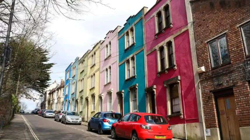
Totterdown is known for steep residential streets because the neighbourhood occupies rising ground south of the River Avon and Temple Meads. Dense rows of terraced houses follow this topography, while brightly painted façades create one of Bristol’s most recognisable residential streetscapes.
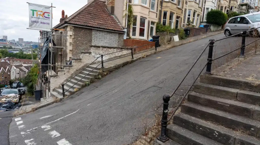
Topography is central to understanding Totterdown. The neighbourhood rises sharply from the lower ground around Temple Meads and the River Avon corridor.
The steep gradient affects almost every aspect of the area. Walking routes involve significant changes in elevation. Cycling requires additional effort on uphill streets. Views become wider as streets climb.
Vale Street is particularly well known for its gradient. VisitBristol describes it as reportedly the steepest residential street in England. The street has become one of the area’s most recognisable visual features.
The houses add another layer of visual identity. Rows of closely spaced terraces occupy the slopes. Many properties feature painted façades, traditional architectural details and compact frontages.
This built form also reflects nineteenth-century urban development. Bristol’s historic neighbourhoods contain distinct architectural patterns shaped by topography, building materials, land use and social development. Bristol City Council uses these characteristics when assessing neighbourhood character.
The combination of steep streets and dense terraces makes Totterdown visually different from flatter areas of Bristol.
What types of homes are found in Totterdown?
Totterdown is dominated by traditional terraced housing, particularly compact Victorian and Edwardian-era properties arranged along steep streets. The housing stock also includes converted homes, flats, modern properties and buildings adapted for contemporary residential use.
Terraced housing forms the strongest architectural identity of Totterdown. Properties commonly stand in continuous or closely spaced rows, reflecting the efficient urban development patterns associated with nineteenth-century Bristol.
Many houses have relatively narrow frontages. Their layouts respond to the steep terrain and historic street pattern. Front doors often open directly onto pavements or small front gardens.
The age and construction of properties create practical considerations for residents. Older houses can contain traditional masonry, timber features, sash windows, pitched roofs and compact internal layouts.
Some properties have been converted into flats or divided into multiple residential units. Others have been modernised while retaining their external façades.
Housing demand is connected to the neighbourhood’s location. Temple Meads provides rail connections, while central Bristol is accessible on foot and by local transport.
Totterdown should also be understood within the wider south Bristol housing market. Nearby Bedminster, Windmill Hill and Knowle contain different housing types and densities. The boundaries between these neighbourhoods can feel less distinct on the ground than on maps.
For exact property information, Bristol City Council’s My Neighbourhood service provides address-level information including planning, parking and local facilities.
What is everyday life like in Totterdown?
Everyday life in Totterdown combines residential streets with independent cafés, restaurants, pubs, green spaces and convenient access to central Bristol. The neighbourhood supports local routines while remaining closely connected to major employment, shopping, cultural and transport destinations.
Totterdown has a strongly residential character. Local streets contain homes, small businesses and community facilities rather than large commercial centres.
Independent businesses form an important part of daily activity. VisitBristol highlights cafés, pubs, restaurants and other local venues within Totterdown and the surrounding south Bristol neighbourhoods.
The neighbourhood also benefits from nearby green space. Victoria Park provides lawns, recreational facilities, children’s play areas, tennis courts, a bowling green and a measured 1,700-metre walking, jogging and running route. Bristol City Council records the park as open at all times and identifies its location in Bedminster alongside Totterdown.
Arnos Vale Cemetery is another nearby destination. It provides historic buildings, nature trails and green space within walking distance of Totterdown. VisitBristol describes the cemetery as approximately 170 years old and accessible from the neighbourhood.
The combination of homes, local businesses and nearby open spaces supports a neighbourhood pattern rather than a purely commuter environment.
What food and drink can you find in Totterdown?
Totterdown has a varied local food and drink scene that includes cafés, restaurants, pubs, pizza, fish and chips, small breweries and neighbourhood bars. Independent venues are concentrated around residential streets and provide everyday dining as well as evening options.
Food is one of Totterdown’s strongest visitor and resident attractions. The area contains independent venues rather than a single large shopping and dining district.
VisitBristol identifies BANK Restaurant as a notable Totterdown restaurant serving small plates cooked over live fire. The same source identifies Bruhaha as a local nano brewery and bar.
The wider neighbourhood also contains traditional pubs and casual food businesses. VisitBristol’s local guide lists venues including The Oxford, The Shakespeare, The New Found Out, Star & Dove and The Thunderbolt.
Café culture is also part of the area’s identity. Independent coffee shops provide daytime options, while pubs and restaurants create evening activity.
The presence of a local brewery adds another element to the food and drink offer. VisitBristol lists Bruhaha’s nano brewery taproom among Bristol’s brewing destinations.
Because businesses change over time, visitors should check individual venue opening hours before travelling. The broader pattern remains consistent: Totterdown provides a compact selection of independent food, drink and hospitality businesses close to residential streets.
What can visitors do in Totterdown?
Visitors can explore Totterdown’s steep streets, photograph its colourful terraces, enjoy independent cafés and restaurants, visit Victoria Park, walk towards Arnos Vale Cemetery and connect the neighbourhood with Temple Meads and central Bristol.
Walking is the most direct way to understand the neighbourhood. The steep streets reveal different views as the elevation changes.
Vale Street provides a particularly recognisable route. Other residential streets offer views of painted terraces, small gardens, street art and local architectural details.
Victoria Park is an important nearby destination. Bristol City Council records facilities including children’s play areas, tennis courts, a bowling green, an outdoor gym, a skate and wheels park and a marked 1,700-metre route.
Arnos Vale Cemetery provides another route for exploration. Its combination of historic cemetery architecture, mature vegetation and walking trails creates a different environment from the surrounding residential streets.
Food and drink provide another reason to explore. Visitors can combine a walk through the streets with cafés, restaurants, pubs and local brewing venues.
Totterdown also works well as part of a wider south Bristol itinerary. Bedminster, Southville, Temple Meads and the city centre are all connected through nearby walking and transport routes.
How close is Totterdown to Bristol Temple Meads?
Totterdown is immediately south and south-east of Bristol Temple Meads, making the railway station one of its most important transport connections. The station provides regional and national rail services and links the neighbourhood with Bristol’s wider transport network.
Temple Meads is one of Britain’s significant railway stations and a major gateway to Bristol. Bristol City Council describes it as a nationally significant transport interchange and the gateway to Bristol and the wider West of England.
The station’s history extends back to Brunel’s Great Western Railway. The original station dates from 1839–1841, followed by later nineteenth-century development and twentieth-century extensions.
This proximity is important for both residents and visitors. Rail passengers can reach Totterdown without crossing large parts of Bristol before entering the neighbourhood.
The station also connects Totterdown with employment and education destinations beyond Bristol. Rail travel provides access towards cities and towns across the South West and beyond.
Temple Meads itself is undergoing major investment. Bristol City Council’s current plans include improved entrances, public spaces, accessibility, cycle facilities and connections with surrounding neighbourhoods.
These transport changes are relevant to Totterdown because the neighbourhood’s northern edge directly interacts with the Temple Meads area.
How accessible is Totterdown by bus, walking and cycling?
Totterdown has strong connections with central Bristol through walking, local bus services and nearby transport corridors. Its steep terrain affects cycling and walking, while proximity to Temple Meads provides an additional rail connection for longer journeys.
Walking is practical for reaching Temple Meads and central Bristol, although the area’s hills influence journey times and physical effort.
VisitBristol confirms that several bus routes connect Totterdown and Bedminster with Bristol city centre and other parts of the city.
Cycling is possible but the topography is an important consideration. Streets with significant gradients require more physical effort than flatter routes elsewhere in Bristol.
Transport planning is also changing. Bristol City Council’s 2026 revised proposals for the South Bristol Liveable Neighbourhood include changes affecting Totterdown, including one-way and direction changes, a proposed modal filter on William Street, timed closure options on Bellevue Road and a proposed bus gate on St Lukes Road.
These proposals form part of wider transport planning and should not be treated as completed infrastructure unless confirmed by the council.
For visitors, Temple Meads remains the clearest major transport gateway. From there, Totterdown can be incorporated into a walking itinerary through south Bristol.
What green spaces are near Totterdown?
Victoria Park is the principal green space associated with Totterdown, while Arnos Vale Cemetery provides another nearby landscape for walking and nature. Together, these spaces add recreation, greenery and outdoor activity to the dense residential environment.
Victoria Park is a large Victorian park serving Totterdown and neighbouring Bedminster. Bristol City Council lists grassed areas, children’s play facilities, tennis courts, a bowling green, toilets, a café and a marked 1,700-metre route.
The park is also notably hilly. Bristol City Council specifically identifies its terrain as challenging for some wheelchair users and people with disabilities.
Arnos Vale Cemetery provides a different type of green environment. It combines historic cemetery architecture with trees, paths, wildlife habitat and visitor facilities.
These spaces are important because Totterdown has a relatively dense urban form. Parks and landscaped areas provide places for walking, recreation, exercise and informal outdoor activity.
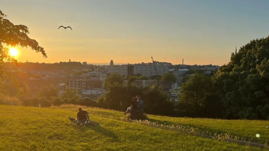
The nearby parks also contribute to the visitor experience. Elevated sections of Victoria Park provide views towards Bristol’s urban landscape, reinforcing the relationship between Totterdown’s topography and its surrounding cityscape.
Does Totterdown have important heritage sites?
Totterdown’s heritage includes historic residential streets, its relationship with Temple Meads, and the nearby Totterdown Basin and River Avon infrastructure. The surrounding area contains nationally listed railway buildings and historic industrial assets associated with Bristol’s transport development.
The heritage context extends beyond individual houses. Totterdown forms part of a wider historic landscape shaped by railways, waterways, industry and nineteenth-century urban growth.
Temple Meads is particularly significant. The original Brunel station, later Digby Wyatt station and associated structures are Grade I listed. Bristol City Council describes the station as having the highest national historical significance.
Totterdown Basin is another important heritage feature. Bristol City Council’s River Avon Heritage Assessment identifies the basin, remains of the entrance lock and associated dockside fabric as historically significant.
The assessment also records the former gas works building and Marble Mosaic Warehouse as Grade II listed assets within the wider setting.
Bristol has 33 conservation areas, although Totterdown itself should not automatically be described as one. Conservation-area status applies to designated areas with defined boundaries. Bristol City Council provides mapping and planning information for checking individual properties and locations.
This distinction matters for property owners. Heritage significance, listed-building status and conservation-area controls are different planning concepts.
Explore More Area Guide
Southville Area Guide: History, Things to Do & Living in Bristol
Bedminster Area Guide: History, Attractions, Food and Transport
How is Totterdown changing?
Totterdown is changing through transport planning, investment around Temple Meads and continuing adaptation of older residential and commercial buildings. Future development is shaped by Bristol’s wider objectives for sustainable transport, housing, accessibility and urban regeneration.
The neighbourhood’s location places it close to major regeneration activity around Temple Meads and Temple Quarter.
Bristol City Council’s Temple Quarter programme includes improvements to Temple Meads, new entrances, better public spaces, cycle infrastructure, accessibility measures and development opportunities around the station.
These projects have wider implications for neighbouring communities because transport connections and public-realm improvements influence how people move between the station and surrounding districts.
Totterdown is also included within South Bristol Liveable Neighbourhood planning. Revised 2026 proposals include traffic-management changes and walking, cycling and public-transport measures.
The neighbourhood’s historic housing creates another long-term consideration. Older buildings require maintenance and sensitive adaptation. Bristol City Council’s heritage framework recognises that neighbourhood character is influenced by topography, landscape, views, architecture, materials and social development.
Future changes therefore involve both modern infrastructure and the preservation of established urban character.
Why is Totterdown important within Bristol?
Totterdown is important because it combines historic housing, steep urban topography, independent businesses, green spaces and immediate access to Temple Meads. Its location connects residential south Bristol with the city’s railway, cultural, commercial and regeneration networks.
Totterdown represents an important part of Bristol’s inner-city residential landscape. Its streets show how nineteenth-century urban growth adapted to difficult terrain.
Its proximity to Temple Meads adds strategic importance. The station connects Bristol with regional and national destinations while forming a major gateway into the city.
Its independent businesses support the local economy and provide cafés, restaurants, pubs and specialist venues. VisitBristol identifies the wider Southville, Bedminster and Totterdown area as a destination with independent shops, restaurants, bars, markets, parks and urban culture.
Its green spaces provide another layer of value. Victoria Park offers structured recreation, while Arnos Vale provides heritage and nature close to the residential streets.
Its visual character is also distinctive. Steep streets and colourful terraces create recognisable views across south Bristol.
For residents, Totterdown combines central accessibility with a strong neighbourhood identity. For visitors, it provides an alternative way to experience Bristol beyond the principal central attractions.
For the future, transport improvements around Temple Meads and South Bristol will continue to influence the area’s accessibility and public realm. The balance between new infrastructure and established neighbourhood character will remain important to Totterdown’s development.
Where is Totterdown in Bristol?
Totterdown is a residential neighbourhood in south Bristol, close to Bristol Temple Meads, Bedminster, Windmill Hill and Knowle. It sits on rising ground south of the River Avon.